
IMAGES TAKEN NEAR TO
Orchard Road, WESTBURY, BA13 3EJ
Introduction
This page details the photographs taken nearby to Orchard Road, BA13 3EJ by members of the Geograph project.
The Geograph project started in 2005 with the aim of publishing, organising and preserving representative images for every square kilometre of Great Britain, Ireland and the Isle of Man.

There are currently over 7.5m images from over14,400 individuals and you can help contribute to the project by visiting https://www.geograph.org.uk
Image Map
Images are licensed for reuse under creativecommons.org/licenses/by-sa/2.0
Notes
- Clicking on the map will re-center to the selected point.
- The higher the marker number, the further away the image location is from the centre of the postcode.
Image Listing (189 Images Found)
Images are licensed for reuse under creativecommons.org/licenses/by-sa/2.0
Image
Details
Distance
1
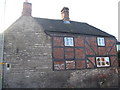
Bereswell Cottage
This timber framed building lies on Bratton Road near its junction with Edward Street and Warminster Road. Apparently a spring rises beneath it and is carried under the road and then by underground culvert down Church street.
Image: © Phil Williams
Taken: 17 Dec 2005
0.02 miles
2
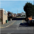
Orchard Road, Westbury
Viewed across Warminster Road.
Image: © Jaggery
Taken: 8 Mar 2014
0.03 miles
3
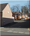
Vista Court, Westbury
A 60 metre long cul-de-sac viewed across Warminster Road.
Image: © Jaggery
Taken: 8 Mar 2014
0.05 miles
4
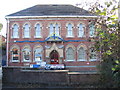
Laverton Hall , Westbury
Looking southeast across Bratton Road from the car park of Westfield House to Laverton Hall. This was built in 1872/3 by local mill owner, Abraham Laverton, and now houses the offices of Westbury Town Council, together with a function suite.
Image: © Phil Williams
Taken: 17 Dec 2005
0.06 miles
5

Snappersnipes, Westbury
This lane provides a useful pedestrian link between Bratton Road and The Butts, Westbury.
Image: © Phil Williams
Taken: 17 Dec 2005
0.06 miles

7

Warminster Road Esso filling station, Westbury
On the corner of Orchard Road. Formerly a Total filling station.
Image: © Jaggery
Taken: 8 Mar 2014
0.07 miles
8
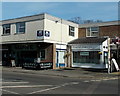
Tale of Spice II, Westbury
On the corner of Warminster Road and Orchard Road, Tale of Spice II (or Tale of Spice 2) describes itself as "Executive Indian Cuisine". The first Tale of Spice opened in Trowbridge. The business's second Tale of Spice opened here in Westbury in 2001, hence the name. Suave coffee house and wine bar is on the left.
Image: © Jaggery
Taken: 8 Mar 2014
0.07 miles
9

Prospect Place
A view looking slightly north of west, over the green at Prospect Place. The large white building just off centre in the distance is the United Dairies milk processing plant on the West Wilts Trading Estate.
Image: © Phil Williams
Taken: 28 Jan 2006
0.07 miles
10

Shy telephone box
This example of the old style red telephone box, adjacent to the Champion take-away, seems to be a bit of a shrinking violet.
Image: © Phil Williams
Taken: 25 Feb 2006
0.07 miles