IMAGES TAKEN NEAR TO
Gibbs Close, WESTBURY, BA13 3DT
Introduction
This page details the photographs taken nearby to Gibbs Close, BA13 3DT by members of the Geograph project.
The Geograph project started in 2005 with the aim of publishing, organising and preserving representative images for every square kilometre of Great Britain, Ireland and the Isle of Man.

There are currently over 7.5m images from over14,400 individuals and you can help contribute to the project by visiting https://www.geograph.org.uk
Image Map (Loading...)


Getting Data...Please wait
Leaflet Map data © OpenStreetMap
Images are licensed for reuse under creativecommons.org/licenses/by-sa/2.0
Notes
- Clicking on the map will re-center to the selected point.
- The higher the marker number, the further away the image location is from the centre of the postcode.
Image Listing (384 Images Found)
Images are licensed for reuse under creativecommons.org/licenses/by-sa/2.0
Image
Details
Distance
1
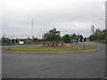
Floral display on the Mead roundabout
A view of the floral display on the Mead roundabout at the junction of the A350 and the B3098on the approach to Westbury from Trowbridge.
The white banner on the fence relates to the threatened closure of the local community hospital due to PCT budget deficits.
Image: © Phil Williams
Taken: 11 Sep 2005
0.06 miles
2
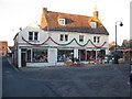
Air Ambulance shop, Westbury
Looking north to the Air Ambulance charity shop at the end of Maristow Street, Westbury.
Image: © Phil Williams
Taken: 12 Dec 2005
0.06 miles
3
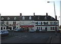
Market Place , Westbury
looking west to the entrance to the market place, Westbury. The A350 is to the right of the building at the end of the terrace.
Image: © Phil Williams
Taken: 12 Dec 2005
0.06 miles
4
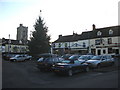
Market Place, Westbury
looking southwest across the market place, Westbury. The tower of All saints church can be seen to the left of the Christmas tree.
Image: © Phil Williams
Taken: 12 Dec 2005
0.06 miles
5
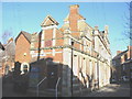
Westbury Swimming Pool
Looking east along Church Street, the Victorian building housing westbury swimming pool is on the left.
Image: © Phil Williams
Taken: 17 Dec 2005
0.06 miles
6
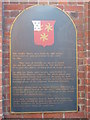
Westbury Swimming Pool
This plaque on the wall of the swimming pool at Westbury explains its history better than I can!
Image: © Phil Williams
Taken: 17 Dec 2005
0.06 miles
7
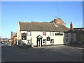
Edward Street, Westbury
looking north down Edward Street, Westbury. The Angel public house occupies a position at the junction with Church Street, and takes its name from the mill whose building tower behind it.
Image: © Phil Williams
Taken: 17 Dec 2005
0.06 miles
8
Edward Street, Westbury
Looking slightly west of north, along Edward Street, Westbury, from the Angel public house at the corner of Church Street. The large number of yellow jackets at the exit from the Coopers store is not a security incident, merely the local Lions club collecting in connection with their Santa grotto, which is just out of sight at left.
Image: © Phil Williams
Taken: 17 Dec 2005
0.06 miles
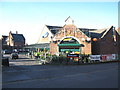
9

Oddfellows Hall, Westbury
Looking southeast along Bratton Road, Westbury, Oddfellows Hall is on the left. The large building in the distance is the Laverton Hall.
Image: © Phil Williams
Taken: 17 Dec 2005
0.06 miles
10
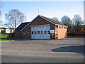
Fire Station, Westbury
Looking southeast across Meadow Lane and the forecourt of the Fire Station. The boundary of this square passes just in front of the building!
Image: © Phil Williams
Taken: 17 Dec 2005
0.06 miles