
IMAGES TAKEN NEAR TO
Market Place, WESTBURY, BA13 3DG
Introduction
This page details the photographs taken nearby to Market Place, BA13 3DG by members of the Geograph project.
The Geograph project started in 2005 with the aim of publishing, organising and preserving representative images for every square kilometre of Great Britain, Ireland and the Isle of Man.

There are currently over 7.5m images from over14,400 individuals and you can help contribute to the project by visiting https://www.geograph.org.uk
Image Map
Images are licensed for reuse under creativecommons.org/licenses/by-sa/2.0
Notes
- Clicking on the map will re-center to the selected point.
- The higher the marker number, the further away the image location is from the centre of the postcode.
Image Listing (442 Images Found)
Images are licensed for reuse under creativecommons.org/licenses/by-sa/2.0
Image
Details
Distance
1
![Westbury buildings [34]](https://s0.geograph.org.uk/geophotos/06/83/26/6832612_87d2733f_120x120.jpg)
Westbury buildings [34]
This 18th century house at number 23 Market Place has two 20th century shop fronts under a common facia. Built of brick which has been rendered and incised to represent ashlar, with a tiled roof. There is a rear extension. Listed, grade II, with details at: https://historicengland.org.uk/listing/the-list/list-entry/1285118
Westbury is a former market town in the far west of Wiltshire under the north western edge of Salisbury Plain, 4 miles south of Trowbridge and 4 miles north of Warminster. Westbury was a centre of the cloth industry from the later 15th century until the 19th century. Malting was another important industry. There are now a number of large industrial and trading estates around the town with many residents working there. The town is an important junction point on the railway network with the Reading to Taunton line intersecting the line from Bristol to Southampton.
Image: © Michael Dibb
Taken: 29 Apr 2021
0.00 miles
2
![Westbury houses [51]](https://s0.geograph.org.uk/geophotos/06/83/26/6832616_f083e232_120x120.jpg)
Westbury houses [51]
Number 22 Market Place is 18th century. Built of brick which has been rendered and incised to represent ashlar, with a tiled roof. The fenestration is irregular. Listed, grade II, with details at: https://historicengland.org.uk/listing/the-list/list-entry/1036307
Westbury is a former market town in the far west of Wiltshire under the north western edge of Salisbury Plain, 4 miles south of Trowbridge and 4 miles north of Warminster. Westbury was a centre of the cloth industry from the later 15th century until the 19th century. Malting was another important industry. There are now a number of large industrial and trading estates around the town with many residents working there. The town is an important junction point on the railway network with the Reading to Taunton line intersecting the line from Bristol to Southampton.
Image: © Michael Dibb
Taken: 29 Apr 2021
0.00 miles
3
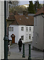
Horse sense
You can lead a horse...
Looking along Alfred Street, with the famous white horse as a beacon on the hillside.
Image: © Neil Owen
Taken: 26 Feb 2014
0.01 miles
4
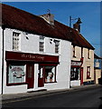
New China Cottage and Magic Wok, Westbury
Adjacent Chinese takeaways on the north side of Market Place.
Image: © Jaggery
Taken: 8 Mar 2014
0.01 miles
5
![Westbury buildings [33]](https://s2.geograph.org.uk/geophotos/06/83/26/6832610_a9cda093_120x120.jpg)
Westbury buildings [33]
Built as a house in the 18th century, number 24 Market Place is constructed in brick, now pebbledashed, under a tiled roof. The shop front is late 19th century. There is a rear extension. Listed, grade II, with details at: https://historicengland.org.uk/listing/the-list/list-entry/1364398
Westbury is a former market town in the far west of Wiltshire under the north western edge of Salisbury Plain, 4 miles south of Trowbridge and 4 miles north of Warminster. Westbury was a centre of the cloth industry from the later 15th century until the 19th century. Malting was another important industry. There are now a number of large industrial and trading estates around the town with many residents working there. The town is an important junction point on the railway network with the Reading to Taunton line intersecting the line from Bristol to Southampton.
Image: © Michael Dibb
Taken: 29 Apr 2021
0.01 miles
6
![Westbury buildings [36]](https://s3.geograph.org.uk/geophotos/06/83/26/6832619_e0448e1b_120x120.jpg)
Westbury buildings [36]
Numbers 20 and 21 Market Place occupy an early 18th century corner block with a curved corner. Built of brick which has been rendered and incised to represent ashlar, with a tiled roof. This is the front to Fore Street, the front to Market Place is seen at Image Listed, grade II, with details at: https://historicengland.org.uk/listing/the-list/list-entry/1181218
Westbury is a former market town in the far west of Wiltshire under the north western edge of Salisbury Plain, 4 miles south of Trowbridge and 4 miles north of Warminster. Westbury was a centre of the cloth industry from the later 15th century until the 19th century. Malting was another important industry. There are now a number of large industrial and trading estates around the town with many residents working there. The town is an important junction point on the railway network with the Reading to Taunton line intersecting the line from Bristol to Southampton.
Image: © Michael Dibb
Taken: 29 Apr 2021
0.01 miles
7
![Westbury buildings [42]](https://s3.geograph.org.uk/geophotos/06/83/35/6833587_8a08c46b_120x120.jpg)
Westbury buildings [42]
The Ludlow Arms in Fore Street was built in the late 18th or early 19th century. Constructed of brick with stone quoins and dressings to the pointed arch windows, under an old tile roof. Listed, grade II, with details at: https://historicengland.org.uk/listing/the-list/list-entry/1364397
Fore Street suffers from being part of the busy A350 which runs through the town with a constant stream of heavy goods vehicles.
Westbury is a former market town in the far west of Wiltshire under the north western edge of Salisbury Plain, 4 miles south of Trowbridge and 4 miles north of Warminster. Westbury was a centre of the cloth industry from the later 15th century until the 19th century. Malting was another important industry. There are now a number of large industrial and trading estates around the town with many residents working there. The town is an important junction point on the railway network with the Reading to Taunton line intersecting the line from Bristol to Southampton.
Image: © Michael Dibb
Taken: 29 Apr 2021
0.01 miles
8
![Westbury houses [53]](https://s0.geograph.org.uk/geophotos/06/83/35/6833588_5230fae9_120x120.jpg)
Westbury houses [53]
Originally two cottages, now one, number 4 Fore Street is 18th century. Built of brick on a rubble stone plinth with an old tile roof. Listed, grade II, with details at: https://historicengland.org.uk/listing/the-list/list-entry/1285143
Fore Street suffers from being part of the busy A350 which runs through the town with a constant stream of heavy goods vehicles.
Westbury is a former market town in the far west of Wiltshire under the north western edge of Salisbury Plain, 4 miles south of Trowbridge and 4 miles north of Warminster. Westbury was a centre of the cloth industry from the later 15th century until the 19th century. Malting was another important industry. There are now a number of large industrial and trading estates around the town with many residents working there. The town is an important junction point on the railway network with the Reading to Taunton line intersecting the line from Bristol to Southampton.
Image: © Michael Dibb
Taken: 29 Apr 2021
0.01 miles
9
![Westbury buildings [32]](https://s1.geograph.org.uk/geophotos/06/83/13/6831309_2a52867a_120x120.jpg)
Westbury buildings [32]
Number 25 Market Place is adjacent to the former town hall Image Built in the 18th century in brick, now pebbledashed, with a pantile roof. There are extensions at the rear fronting Albert Street. Listed, grade II, with details at: https://historicengland.org.uk/listing/the-list/list-entry/1181229
Westbury is a former market town in the far west of Wiltshire under the north western edge of Salisbury Plain, 4 miles south of Trowbridge and 4 miles north of Warminster. Westbury was a centre of the cloth industry from the later 15th century until the 19th century. Malting was another important industry. There are now a number of large industrial and trading estates around the town with many residents working there. The town is an important junction point on the railway network with the Reading to Taunton line intersecting the line from Bristol to Southampton.
Image: © Michael Dibb
Taken: 29 Apr 2021
0.01 miles
10
![Westbury buildings [35]](https://s2.geograph.org.uk/geophotos/06/83/26/6832618_10ef7685_120x120.jpg)
Westbury buildings [35]
Numbers 20 and 21 Market Place occupy an early 18th century corner block with a curved corner. Built of brick which has been rendered and incised to represent ashlar, with a tiled roof. This is the front to Market Place, the front to Fore Street is seen at Image Listed, grade II, with details at: https://historicengland.org.uk/listing/the-list/list-entry/1181218
Westbury is a former market town in the far west of Wiltshire under the north western edge of Salisbury Plain, 4 miles south of Trowbridge and 4 miles north of Warminster. Westbury was a centre of the cloth industry from the later 15th century until the 19th century. Malting was another important industry. There are now a number of large industrial and trading estates around the town with many residents working there. The town is an important junction point on the railway network with the Reading to Taunton line intersecting the line from Bristol to Southampton.
Image: © Michael Dibb
Taken: 29 Apr 2021
0.01 miles