IMAGES TAKEN NEAR TO
Market Place, WESTBURY, BA13 3DE
Introduction
This page details the photographs taken nearby to Market Place, BA13 3DE by members of the Geograph project.
The Geograph project started in 2005 with the aim of publishing, organising and preserving representative images for every square kilometre of Great Britain, Ireland and the Isle of Man.

There are currently over 7.5m images from over14,400 individuals and you can help contribute to the project by visiting https://www.geograph.org.uk
Image Map
Images are licensed for reuse under creativecommons.org/licenses/by-sa/2.0
Notes
- Clicking on the map will re-center to the selected point.
- The higher the marker number, the further away the image location is from the centre of the postcode.
Image Listing (451 Images Found)
Images are licensed for reuse under creativecommons.org/licenses/by-sa/2.0
Image
Details
Distance
1
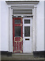
Red and white halves
A door in the White Lion pub, twin coloured.
Image: © Neil Owen
Taken: 26 Feb 2014
0.00 miles
2
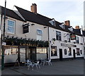
Charlies Bar and The Crown Inn, Westbury
On the west side of Market Place.
Image: © Jaggery
Taken: 8 Mar 2014
0.00 miles
3
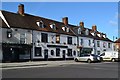
Market Place, Westbury
With The Crown Inn in the centre of the image.
Image: © David Martin
Taken: 1 Oct 2018
0.00 miles
4
![Westbury buildings [38]](https://s1.geograph.org.uk/geophotos/06/83/26/6832629_f3149c9b_120x120.jpg)
Westbury buildings [38]
Number 7 Market Place is late 18th or early 19th century. Built of brick, now rendered, with a slate roof. The shop front is modern. Listed, for group value, grade II, with details at: https://historicengland.org.uk/listing/the-list/list-entry/1036305
Westbury is a former market town in the far west of Wiltshire under the north western edge of Salisbury Plain, 4 miles south of Trowbridge and 4 miles north of Warminster. Westbury was a centre of the cloth industry from the later 15th century until the 19th century. Malting was another important industry. There are now a number of large industrial and trading estates around the town with many residents working there. The town is an important junction point on the railway network with the Reading to Taunton line intersecting the line from Bristol to Southampton.
Image: © Michael Dibb
Taken: 29 Apr 2021
0.00 miles
5
![Westbury buildings [37]](https://s3.geograph.org.uk/geophotos/06/83/26/6832623_408391df_120x120.jpg)
Westbury buildings [37]
This late 18th century building is the former White Lion public house. The pub closed in 2010 and was converted into apartments. Constructed of brick, now stuccoed, with an old tile roof. Listed, grade II, with details at: https://historicengland.org.uk/listing/the-list/list-entry/1181204
This image also shows the K6 telephone box (seen in detail at Image) in context.
Westbury is a former market town in the far west of Wiltshire under the north western edge of Salisbury Plain, 4 miles south of Trowbridge and 4 miles north of Warminster. Westbury was a centre of the cloth industry from the later 15th century until the 19th century. Malting was another important industry. There are now a number of large industrial and trading estates around the town with many residents working there. The town is an important junction point on the railway network with the Reading to Taunton line intersecting the line from Bristol to Southampton.
Image: © Michael Dibb
Taken: 29 Apr 2021
0.01 miles
6
![Westbury features [11]](https://s1.geograph.org.uk/geophotos/06/83/26/6832625_715e913f_120x120.jpg)
Westbury features [11]
A K6 telephone box, designed in 1935 by Sir Giles Gilbert Scott. Located outside the former White Lion public house - see Image Listed, grade II, with details at: https://historicengland.org.uk/listing/the-list/list-entry/1036333
Westbury is a former market town in the far west of Wiltshire under the north western edge of Salisbury Plain, 4 miles south of Trowbridge and 4 miles north of Warminster. Westbury was a centre of the cloth industry from the later 15th century until the 19th century. Malting was another important industry. There are now a number of large industrial and trading estates around the town with many residents working there. The town is an important junction point on the railway network with the Reading to Taunton line intersecting the line from Bristol to Southampton.
Image: © Michael Dibb
Taken: 29 Apr 2021
0.01 miles
7
![Westbury buildings [39]](https://s3.geograph.org.uk/geophotos/06/83/26/6832631_d9e991be_120x120.jpg)
Westbury buildings [39]
The Crown Inn, Market Place is late 18th century. Constructed of brick under an old tile roof. Listed, grade II, with details at: https://historicengland.org.uk/listing/the-list/list-entry/1181200
Westbury is a former market town in the far west of Wiltshire under the north western edge of Salisbury Plain, 4 miles south of Trowbridge and 4 miles north of Warminster. Westbury was a centre of the cloth industry from the later 15th century until the 19th century. Malting was another important industry. There are now a number of large industrial and trading estates around the town with many residents working there. The town is an important junction point on the railway network with the Reading to Taunton line intersecting the line from Bristol to Southampton.
Image: © Michael Dibb
Taken: 29 Apr 2021
0.01 miles
8
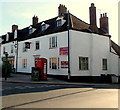
The White Lion apartments, Westbury
The former White Lion pub in Market Place has been converted to apartments.
Image: © Jaggery
Taken: 8 Mar 2014
0.01 miles
9
![Westbury buildings [35]](https://s2.geograph.org.uk/geophotos/06/83/26/6832618_10ef7685_120x120.jpg)
Westbury buildings [35]
Numbers 20 and 21 Market Place occupy an early 18th century corner block with a curved corner. Built of brick which has been rendered and incised to represent ashlar, with a tiled roof. This is the front to Market Place, the front to Fore Street is seen at Image Listed, grade II, with details at: https://historicengland.org.uk/listing/the-list/list-entry/1181218
Westbury is a former market town in the far west of Wiltshire under the north western edge of Salisbury Plain, 4 miles south of Trowbridge and 4 miles north of Warminster. Westbury was a centre of the cloth industry from the later 15th century until the 19th century. Malting was another important industry. There are now a number of large industrial and trading estates around the town with many residents working there. The town is an important junction point on the railway network with the Reading to Taunton line intersecting the line from Bristol to Southampton.
Image: © Michael Dibb
Taken: 29 Apr 2021
0.01 miles
10
![Westbury buildings [40]](https://s2.geograph.org.uk/geophotos/06/83/35/6833582_870a743e_120x120.jpg)
Westbury buildings [40]
Swansdown House, Market Place is late 18th century, built of brick with a tiled roof. The upper storey and roof are extensions of the adjoining buildings. The shop front is late 19th century. Listed, grade II, with details at: https://historicengland.org.uk/listing/the-list/list-entry/1364396
Westbury is a former market town in the far west of Wiltshire under the north western edge of Salisbury Plain, 4 miles south of Trowbridge and 4 miles north of Warminster. Westbury was a centre of the cloth industry from the later 15th century until the 19th century. Malting was another important industry. There are now a number of large industrial and trading estates around the town with many residents working there. The town is an important junction point on the railway network with the Reading to Taunton line intersecting the line from Bristol to Southampton.
Image: © Michael Dibb
Taken: 29 Apr 2021
0.02 miles