IMAGES TAKEN NEAR TO
Church Street, WESTBURY, BA13 3BZ
Introduction
This page details the photographs taken nearby to Church Street, BA13 3BZ by members of the Geograph project.
The Geograph project started in 2005 with the aim of publishing, organising and preserving representative images for every square kilometre of Great Britain, Ireland and the Isle of Man.

There are currently over 7.5m images from over14,400 individuals and you can help contribute to the project by visiting https://www.geograph.org.uk
Image Map (Loading...)


Getting Data...Please wait
Leaflet Map data © OpenStreetMap
Images are licensed for reuse under creativecommons.org/licenses/by-sa/2.0
Notes
- Clicking on the map will re-center to the selected point.
- The higher the marker number, the further away the image location is from the centre of the postcode.
Image Listing (513 Images Found)
Images are licensed for reuse under creativecommons.org/licenses/by-sa/2.0
Image
Details
Distance
1
![Westbury houses [79]](https://s3.geograph.org.uk/geophotos/06/83/90/6839019_b99a315e_120x120.jpg)
Westbury houses [79]
Odd numbers 23 to 33 Church Street are a terrace of six houses, formerly known as numbers 1 to 6 Church Terrace. Built in the early 19th century in red brick on a stone plinth with stone pilasters between the houses. Listed, grade II, with details at: https://historicengland.org.uk/listing/the-list/list-entry/1285422
Westbury is a former market town in the far west of Wiltshire under the north western edge of Salisbury Plain, 4 miles south of Trowbridge and 4 miles north of Warminster. Westbury was a centre of the cloth industry from the later 15th century until the 19th century. Malting was another important industry. There are now a number of large industrial and trading estates around the town with many residents working there. The town is an important junction point on the railway network with the Reading to Taunton line intersecting the line from Bristol to Southampton.
Image: © Michael Dibb
Taken: 29 Apr 2021
0.01 miles
2
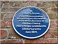
Plaque in Church Street
The solicitors are still there
Image: © Basher Eyre
Taken: 22 Aug 2016
0.01 miles
3
![Westbury buildings [59]](https://s2.geograph.org.uk/geophotos/06/83/99/6839922_3f0cdb10_120x120.jpg)
Westbury buildings [59]
Number 35 Church Street is a large early 19th century building incorporating parts of a medieval house. Built on a 'L' shaped plan with three gabled rear extensions. Constructed in red brick on a stone plinth with a slate roof. There is a Doric porch. Inside is a two bay arch braced collar-beam roofed room called The Chapel. There is a view of the rear of the building at Image See also Image Listed, grade II, with details at: https://historicengland.org.uk/listing/the-list/list-entry/1036286
Westbury is a former market town in the far west of Wiltshire under the north western edge of Salisbury Plain, 4 miles south of Trowbridge and 4 miles north of Warminster. Westbury was a centre of the cloth industry from the later 15th century until the 19th century. Malting was another important industry. There are now a number of large industrial and trading estates around the town with many residents working there. The town is an important junction point on the railway network with the Reading to Taunton line intersecting the line from Bristol to Southampton.
Image: © Michael Dibb
Taken: 29 Apr 2021
0.01 miles
4
![Westbury buildings [60]](https://s3.geograph.org.uk/geophotos/06/83/99/6839923_b4137d9c_120x120.jpg)
Westbury buildings [60]
Number 35 Church Street is a large early 19th century building incorporating parts of a medieval house. Built on a 'L' shaped plan with three gabled rear extensions. Constructed in red brick on a stone plinth with a slate roof. There is a Doric porch. Inside is a two bay arch braced collar-beam roofed room called The Chapel. There is a view of the front of the building at Image See also Image Listed, grade II, with details at: https://historicengland.org.uk/listing/the-list/list-entry/1036286
Westbury is a former market town in the far west of Wiltshire under the north western edge of Salisbury Plain, 4 miles south of Trowbridge and 4 miles north of Warminster. Westbury was a centre of the cloth industry from the later 15th century until the 19th century. Malting was another important industry. There are now a number of large industrial and trading estates around the town with many residents working there. The town is an important junction point on the railway network with the Reading to Taunton line intersecting the line from Bristol to Southampton.
Image: © Michael Dibb
Taken: 29 Apr 2021
0.02 miles
5
![Westbury buildings [61]](https://s0.geograph.org.uk/geophotos/06/83/99/6839924_22e53f0a_120x120.jpg)
Westbury buildings [61]
Number 35 Church Street is a large early 19th century building incorporating parts of a medieval house. Built on a 'L' shaped plan with three gabled rear extensions. Constructed in red brick on a stone plinth with a slate roof. There is a Doric porch. Inside is a two bay arch braced collar-beam roofed room called The Chapel. There are views of the building at Image and at Image Listed, grade II, with details at: https://historicengland.org.uk/listing/the-list/list-entry/1036286
Westbury is a former market town in the far west of Wiltshire under the north western edge of Salisbury Plain, 4 miles south of Trowbridge and 4 miles north of Warminster. Westbury was a centre of the cloth industry from the later 15th century until the 19th century. Malting was another important industry. There are now a number of large industrial and trading estates around the town with many residents working there. The town is an important junction point on the railway network with the Reading to Taunton line intersecting the line from Bristol to Southampton.
Image: © Michael Dibb
Taken: 29 Apr 2021
0.02 miles
6
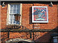
The Lopes Arms
Detail of the plaque on the wall of the Westbury Hotel, recording its previous identity as the Lopes Arms. This coat-of-arms relates to Sir Manasseh Massey Lopes, a former parliamentary representative for Westbury.
Image: © Phil Williams
Taken: 28 Jan 2006
0.02 miles
7
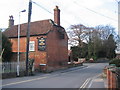
The Horse and Groom
A view looking northwest across Alfred Street to the entrance to Bitham lane footpath and the Horse and Groom public house beyond.
Image: © Phil Williams
Taken: 25 Feb 2006
0.02 miles
8
![Westbury houses [85]](https://s0.geograph.org.uk/geophotos/06/83/99/6839976_4a29ffa3_120x120.jpg)
Westbury houses [85]
Originally three cottages now two, Brookhaven, number 1 Churchyard, and number 1A Churchyard are 18th century. Built of brick on a stone plinth under an old tile roof. Listed, grade II, with details at: https://historicengland.org.uk/listing/the-list/list-entry/1180620
Westbury is a former market town in the far west of Wiltshire under the north western edge of Salisbury Plain, 4 miles south of Trowbridge and 4 miles north of Warminster. Westbury was a centre of the cloth industry from the later 15th century until the 19th century. Malting was another important industry. There are now a number of large industrial and trading estates around the town with many residents working there. The town is an important junction point on the railway network with the Reading to Taunton line intersecting the line from Bristol to Southampton.
Image: © Michael Dibb
Taken: 29 Apr 2021
0.03 miles
9
![Westbury houses [84]](https://s0.geograph.org.uk/geophotos/06/83/99/6839972_84413a6f_120x120.jpg)
Westbury houses [84]
Church View, in Churchyard is 17th or early 18th century. Built of stuccoed brick with an old tile roof. Listed, grade II, with details at: https://historicengland.org.uk/listing/the-list/list-entry/1036288
Westbury is a former market town in the far west of Wiltshire under the north western edge of Salisbury Plain, 4 miles south of Trowbridge and 4 miles north of Warminster. Westbury was a centre of the cloth industry from the later 15th century until the 19th century. Malting was another important industry. There are now a number of large industrial and trading estates around the town with many residents working there. The town is an important junction point on the railway network with the Reading to Taunton line intersecting the line from Bristol to Southampton.
Image: © Michael Dibb
Taken: 29 Apr 2021
0.03 miles
10

All Saints Parish Church, Westbury
The Wiltshire Council website states that a church at Westbury is mentioned in the Domesday Book (1086). It is most likely to have been a Saxon wooden church on this site. The first stone church here was built by the Normans, probably by 1220. The church seen here, using the Norman cruciform plan, is 14th century, probably 1340-1380, in the transitional period between the Decorated and Perpendicular styles.
Image: © Jaggery
Taken: 8 Mar 2014
0.03 miles