IMAGES TAKEN NEAR TO
All Saints Crescent, WESTBURY, BA13 3BX
Introduction
This page details the photographs taken nearby to All Saints Crescent, BA13 3BX by members of the Geograph project.
The Geograph project started in 2005 with the aim of publishing, organising and preserving representative images for every square kilometre of Great Britain, Ireland and the Isle of Man.

There are currently over 7.5m images from over14,400 individuals and you can help contribute to the project by visiting https://www.geograph.org.uk
Image Map
Images are licensed for reuse under creativecommons.org/licenses/by-sa/2.0
Notes
- Clicking on the map will re-center to the selected point.
- The higher the marker number, the further away the image location is from the centre of the postcode.
Image Listing (517 Images Found)
Images are licensed for reuse under creativecommons.org/licenses/by-sa/2.0
Image
Details
Distance
1
![Westbury houses [76]](https://s0.geograph.org.uk/geophotos/06/83/90/6839008_72fee22e_120x120.jpg)
Westbury houses [76]
Ivy House number 15 Church Street and number 15A Church Street were originally one 17th century house, refronted in the 18th century. Built in brick on a stone plinth with a treble Roman pantile roof to number 15 and a mansard roof in old tile to number 15A. Number 15a has a second door to a through passage. There is a large extension to the rear. The roof timbers of both the houses and the extension are massive with large jointed-cruck type trusses. Listed, grade II, with details at: https://historicengland.org.uk/listing/the-list/list-entry/1285459
Westbury is a former market town in the far west of Wiltshire under the north western edge of Salisbury Plain, 4 miles south of Trowbridge and 4 miles north of Warminster. Westbury was a centre of the cloth industry from the later 15th century until the 19th century. Malting was another important industry. There are now a number of large industrial and trading estates around the town with many residents working there. The town is an important junction point on the railway network with the Reading to Taunton line intersecting the line from Bristol to Southampton.
Image: © Michael Dibb
Taken: 29 Apr 2021
0.02 miles
2
![Westbury buildings [58]](https://s1.geograph.org.uk/geophotos/06/83/90/6839005_f4745cb3_120x120.jpg)
Westbury buildings [58]
This small, 18th century former coach house or stable has been converted into living accommodation, number 15B Church Street. Built gable end to the street, in red brick under a pantile roof. Listed, grade II, with details at: https://historicengland.org.uk/listing/the-list/list-entry/1364426
Westbury is a former market town in the far west of Wiltshire under the north western edge of Salisbury Plain, 4 miles south of Trowbridge and 4 miles north of Warminster. Westbury was a centre of the cloth industry from the later 15th century until the 19th century. Malting was another important industry. There are now a number of large industrial and trading estates around the town with many residents working there. The town is an important junction point on the railway network with the Reading to Taunton line intersecting the line from Bristol to Southampton.
Image: © Michael Dibb
Taken: 29 Apr 2021
0.02 miles
3
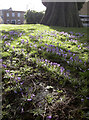
Reaching up to the sunlight
Spring in Westbury - in late February - and the crocuses are enjoying the mild temperatures.
Image: © Neil Owen
Taken: 26 Feb 2014
0.02 miles
4
![Westbury houses [79]](https://s3.geograph.org.uk/geophotos/06/83/90/6839019_b99a315e_120x120.jpg)
Westbury houses [79]
Odd numbers 23 to 33 Church Street are a terrace of six houses, formerly known as numbers 1 to 6 Church Terrace. Built in the early 19th century in red brick on a stone plinth with stone pilasters between the houses. Listed, grade II, with details at: https://historicengland.org.uk/listing/the-list/list-entry/1285422
Westbury is a former market town in the far west of Wiltshire under the north western edge of Salisbury Plain, 4 miles south of Trowbridge and 4 miles north of Warminster. Westbury was a centre of the cloth industry from the later 15th century until the 19th century. Malting was another important industry. There are now a number of large industrial and trading estates around the town with many residents working there. The town is an important junction point on the railway network with the Reading to Taunton line intersecting the line from Bristol to Southampton.
Image: © Michael Dibb
Taken: 29 Apr 2021
0.03 miles
5
![Westbury houses [81]](https://s3.geograph.org.uk/geophotos/06/83/90/6839023_a01ae14d_120x120.jpg)
Westbury houses [81]
Little Chantry, number 32 Church Street is dated 1723 in a stone panel above the door. Built in stuccoed brick with incised lines to give the appearance of ashlar and a pantile roof. Listed, along with number 30 Image, grade II, with details at: https://historicengland.org.uk/listing/the-list/list-entry/1364425
Westbury is a former market town in the far west of Wiltshire under the north western edge of Salisbury Plain, 4 miles south of Trowbridge and 4 miles north of Warminster. Westbury was a centre of the cloth industry from the later 15th century until the 19th century. Malting was another important industry. There are now a number of large industrial and trading estates around the town with many residents working there. The town is an important junction point on the railway network with the Reading to Taunton line intersecting the line from Bristol to Southampton.
Image: © Michael Dibb
Taken: 29 Apr 2021
0.03 miles
6
![Westbury houses [80]](https://s1.geograph.org.uk/geophotos/06/83/90/6839021_47670fe2_120x120.jpg)
Westbury houses [80]
Number 30 Church Street is an 18th century house. Built in stuccoed brick with incised lines to give the appearance of ashlar and a pantile roof. There is a stone panel over the door but the date is obscured. Listed, along with number 32 Image, grade II, with details at: https://historicengland.org.uk/listing/the-list/list-entry/1364425
Westbury is a former market town in the far west of Wiltshire under the north western edge of Salisbury Plain, 4 miles south of Trowbridge and 4 miles north of Warminster. Westbury was a centre of the cloth industry from the later 15th century until the 19th century. Malting was another important industry. There are now a number of large industrial and trading estates around the town with many residents working there. The town is an important junction point on the railway network with the Reading to Taunton line intersecting the line from Bristol to Southampton.
Image: © Michael Dibb
Taken: 29 Apr 2021
0.03 miles
7
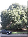
Holme Oak
This specimen of a Holme Oak (Quercus Ilex) stands behind the library and is reputed to have been planted during the construction of All Saints church. This would make it over 600 years old.
Image: © Phil Williams
Taken: 4 Mar 2006
0.03 miles
8
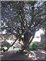
The Holme Oak
A view under the canopy of the Holme Oak in the grounds of the library.
Image: © Phil Williams
Taken: 4 Mar 2006
0.03 miles
9
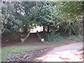
Steps
These rather grand but now redundant steps can be found within the grounds of the library.
Image: © Phil Williams
Taken: 4 Mar 2006
0.03 miles
10
The library (rear)
A view looking west to the rear of the library building.
Image: © Phil Williams
Taken: 4 Mar 2006
0.03 miles