IMAGES TAKEN NEAR TO
High Street, WESTBURY, BA13 3BW
Introduction
This page details the photographs taken nearby to High Street, BA13 3BW by members of the Geograph project.
The Geograph project started in 2005 with the aim of publishing, organising and preserving representative images for every square kilometre of Great Britain, Ireland and the Isle of Man.

There are currently over 7.5m images from over14,400 individuals and you can help contribute to the project by visiting https://www.geograph.org.uk
Image Map
Images are licensed for reuse under creativecommons.org/licenses/by-sa/2.0
Notes
- Clicking on the map will re-center to the selected point.
- The higher the marker number, the further away the image location is from the centre of the postcode.
Image Listing (496 Images Found)
Images are licensed for reuse under creativecommons.org/licenses/by-sa/2.0
Image
Details
Distance
1
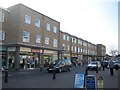
![Westbury ways [13]](https://s2.geograph.org.uk/geophotos/06/83/71/6837102_87d31b28_120x120.jpg)
Westbury ways [13]
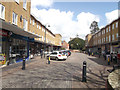
Westbury High Street is a nasty bland 'toothpaste architecture' 1960s retail development. The site was previously occupied by a large house named Fontainville which was taken over by the army during WWII. Temporary huts were erected in the grounds as barracks and, after the war, some council tenants were housed in the huts and the main house fell into disrepair. It was demolished to make way for the High Street. The development was built in two main phases in 1962 and 1966 with more units added later.
Westbury is a former market town in the far west of Wiltshire under the north western edge of Salisbury Plain, 4 miles south of Trowbridge and 4 miles north of Warminster. Westbury was a centre of the cloth industry from the later 15th century until the 19th century. Malting was another important industry. There are now a number of large industrial and trading estates around the town with many residents working there. The town is an important junction point on the railway network with the Reading to Taunton line intersecting the line from Bristol to Southampton.
Image: © Michael Dibb
Taken: 29 Apr 2021
0.01 miles
2
Westbury shopping centre
From High Street
Image: © John Firth
Taken: 11 Apr 2013
0.02 miles
3
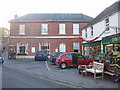
Westbury Library
Looking east to Westbury Library.
Image: © Phil Williams
Taken: 12 Dec 2005
0.03 miles
4
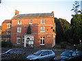
The Garden House Hotel, Westbury
looking west from the tourist information office adjacent to Westbury library to the Garden House Hotel. This building was formerly the town Post Office and has now been given a new lease of life by conversion into a hotel.
Image: © Phil Williams
Taken: 12 Dec 2005
0.03 miles
5

Soissy-sur-Seine Gardens, Westbury
Looking east to Soissy-sur-Seine Gardens, Westbury, named to commemorate a twin town link which has now ended. The white stone at the rear of the green carries a memorial plaque to Diana, Princess of Wales.
Image: © Phil Williams
Taken: 12 Dec 2005
0.03 miles
6
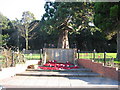
War Memorial, Westbury
Looking east over Edward Street, Westbury, to the war memorial and Soissy-sur-Seine Gardens beyond.
Image: © Phil Williams
Taken: 17 Dec 2005
0.03 miles
7
High Street
A view looking southwest along the High Street.
Image: © Phil Williams
Taken: 21 Jan 2006
0.03 miles
8

High Street
A view looking west along the High Street.
Image: © Phil Williams
Taken: 21 Jan 2006
0.03 miles
9

Yew Stump
A view looking northwest from the library entrance towards Edward Street, showing the stump of the yew tree which was blown down in the storms of january 1990, after providing shelter to the residents of Westbury for over 430 years.
Image: © Phil Williams
Taken: 11 Mar 2006
0.03 miles
10
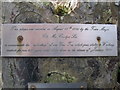
Memorial plaque
A detail view of one of the memorial plaques on the yew stump at Westbury library.
Image: © Phil Williams
Taken: 11 Mar 2006
0.03 miles