IMAGES TAKEN NEAR TO
Edward Street, WESTBURY, BA13 3BA
Introduction
This page details the photographs taken nearby to Edward Street, BA13 3BA by members of the Geograph project.
The Geograph project started in 2005 with the aim of publishing, organising and preserving representative images for every square kilometre of Great Britain, Ireland and the Isle of Man.

There are currently over 7.5m images from over14,400 individuals and you can help contribute to the project by visiting https://www.geograph.org.uk
Image Map (Loading...)


Getting Data...Please wait
Leaflet Map data © OpenStreetMap
Images are licensed for reuse under creativecommons.org/licenses/by-sa/2.0
Notes
- Clicking on the map will re-center to the selected point.
- The higher the marker number, the further away the image location is from the centre of the postcode.
Image Listing (487 Images Found)
Images are licensed for reuse under creativecommons.org/licenses/by-sa/2.0
Image
Details
Distance
1
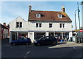
![Westbury houses [66]](https://s0.geograph.org.uk/geophotos/06/83/52/6835268_91a5170c_120x120.jpg)
Westbury houses [66]
Number 4 Edward Street is a mid 19th century house with Gothick ornament. Built of ashlar with a slate roof. The listing includes the garden wall and railings. Listed, grade II, with details at: https://historicengland.org.uk/listing/the-list/list-entry/1036291
Westbury is a former market town in the far west of Wiltshire under the north western edge of Salisbury Plain, 4 miles south of Trowbridge and 4 miles north of Warminster. Westbury was a centre of the cloth industry from the later 15th century until the 19th century. Malting was another important industry. There are now a number of large industrial and trading estates around the town with many residents working there. The town is an important junction point on the railway network with the Reading to Taunton line intersecting the line from Bristol to Southampton.
Image: © Michael Dibb
Taken: 29 Apr 2021
0.01 miles
2
![Westbury buildings [46]](https://s1.geograph.org.uk/geophotos/06/83/52/6835269_64c555b8_120x120.jpg)
Westbury buildings [46]
Number 12 Edward Street is late 18th or early 19th century. Built in brick with a concrete tile roof. Number 12 was once linked if not the same house as number 14. There are three gabled rear extensions, two of which are at back of number 14 and one at back of number 12. Listed, grade II, with details at: https://historicengland.org.uk/listing/the-list/list-entry/1285343
Westbury is a former market town in the far west of Wiltshire under the north western edge of Salisbury Plain, 4 miles south of Trowbridge and 4 miles north of Warminster. Westbury was a centre of the cloth industry from the later 15th century until the 19th century. Malting was another important industry. There are now a number of large industrial and trading estates around the town with many residents working there. The town is an important junction point on the railway network with the Reading to Taunton line intersecting the line from Bristol to Southampton.
Image: © Michael Dibb
Taken: 29 Apr 2021
0.02 miles
3
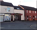
Wiltshire Air Ambulance Appeal shop, Westbury
Charity shop in Maristow Street.
Image: © Jaggery
Taken: 8 Mar 2014
0.02 miles
4
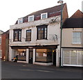
![Westbury buildings [54]](https://s0.geograph.org.uk/geophotos/06/83/79/6837992_8940ed9a_120x120.jpg)
Westbury buildings [54]
Numbers 22 to 26 Maristow Street is a fine mid to late 18th century house, now shop premises. Built in red brick with stone quoins under an old tile roof. The appearance of the building has been improved by the removal of rendering. The shop front is 20th century. The gabled extension on the left is late 19th century. Listed, grade II, with details at: https://historicengland.org.uk/listing/the-list/list-entry/1036303
Westbury is a former market town in the far west of Wiltshire under the north western edge of Salisbury Plain, 4 miles south of Trowbridge and 4 miles north of Warminster. Westbury was a centre of the cloth industry from the later 15th century until the 19th century. Malting was another important industry. There are now a number of large industrial and trading estates around the town with many residents working there. The town is an important junction point on the railway network with the Reading to Taunton line intersecting the line from Bristol to Southampton.
Image: © Michael Dibb
Taken: 29 Apr 2021
0.02 miles
5
Saffron takeaway, Westbury
Indian cuisine takeaway at 10 Edward Street.
Image: © Jaggery
Taken: 8 Mar 2014
0.02 miles
6
![Westbury buildings [47]](https://s2.geograph.org.uk/geophotos/06/83/52/6835270_76745262_120x120.jpg)
Westbury buildings [47]
Numbers 14 and 16 Edward Street is dated 1774. Built of brick under an old tile mansard roof hipped to the left. The angled first floor bay windows originally extended to the ground but were cut off when the shop front was inserted. There are two separate shops with a stairway between leading to accommodation above. Number 14 was once linked if not the same house as number 12. There are three gabled rear extensions, two of which are at back of number 14 and one at back of number 12. Listed, grade II, with details at: https://historicengland.org.uk/listing/the-list/list-entry/1036292
Westbury is a former market town in the far west of Wiltshire under the north western edge of Salisbury Plain, 4 miles south of Trowbridge and 4 miles north of Warminster. Westbury was a centre of the cloth industry from the later 15th century until the 19th century. Malting was another important industry. There are now a number of large industrial and trading estates around the town with many residents working there. The town is an important junction point on the railway network with the Reading to Taunton line intersecting the line from Bristol to Southampton.
Image: © Michael Dibb
Taken: 29 Apr 2021
0.02 miles
7
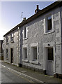
Maristow Street
Sunlight brings out the texture of the rendering and the painted coin stones.
Image: © Neil Owen
Taken: 26 Feb 2014
0.02 miles
8
Mad Hatters tea room, Westbury
The Edward Street business is in premises formerly occupied by The White Rabbit restaurant.
Image: © Jaggery
Taken: 8 Mar 2014
0.02 miles
9
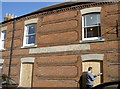
Sealing the place up
Westbury's old Police station in Edward Street, being made secure. The building is clearly not used by the local constabulary as they moved to a new station (in Station Road, appropriately enough) in 1938.
Image: © Neil Owen
Taken: 26 Feb 2014
0.03 miles
10
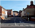
Edward Street, Westbury
Viewed across the A350 West End.
Image: © Jaggery
Taken: 8 Mar 2014
0.03 miles