IMAGES TAKEN NEAR TO
Alfred Street, BATH, BA1 2QU
Introduction
This page details the photographs taken nearby to Alfred Street, BA1 2QU by members of the Geograph project.
The Geograph project started in 2005 with the aim of publishing, organising and preserving representative images for every square kilometre of Great Britain, Ireland and the Isle of Man.

There are currently over 7.5m images from over14,400 individuals and you can help contribute to the project by visiting https://www.geograph.org.uk
Image Map
Images are licensed for reuse under creativecommons.org/licenses/by-sa/2.0
Notes
- Clicking on the map will re-center to the selected point.
- The higher the marker number, the further away the image location is from the centre of the postcode.
Image Listing (978 Images Found)
Images are licensed for reuse under creativecommons.org/licenses/by-sa/2.0
Image
Details
Distance
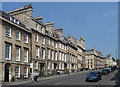
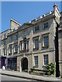
1

1-7 Alfred Street, Bath
The terraces in this and surrounding streets were designed by John Wood the Younger. This group dates from 1768-76. Typical, as in three bays and moulded window architraves. Plain but dignified. Pediments are seen in most of the doorcases and to the central house. Grade II listed.
Image: © Stephen Richards
Taken: 25 May 2012
0.00 miles
2

Benchmark, Lansdown Road
A cut mark, on Lansdown Road by the junction of Albert Street. See http://www.bench-marks.org.uk/bm37539 for the Benchmark Database, and Image] for a view of the area.
Image: © Neil Owen
Taken: 8 Apr 2011
0.01 miles
3

Road up!
The junction of Lansdown Road and Albert Street, Bath. Clearly lots of work is being carried out in various ways. See Image] for the benchmark located on the corner.
Image: © Neil Owen
Taken: 8 Apr 2011
0.01 miles

6
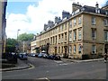
Alfred Street
The house on the corner has an elevation in Alfred Street to match others in the street and a different elevation in Lansdown Road. Built circa 1775 and converted into flats. Listed, grade II, with details at: https://www.historicengland.org.uk/listing/the-list/list-entry/1394225
The terrace of four houses in Alfred Street was built in 1775 and includes one double width property which is a public house. Listed, grade II, with details at: https://www.historicengland.org.uk/listing/the-list/list-entry/1394143
Image: © Michael Dibb
Taken: 2 Jun 2018
0.02 miles

9
1-6 Oxford Row, Lansdown Road, Bath
Six houses built c1775, developed by local builder Thomas Warr Atwood who also practised as an architect so it's likely that he was also responsible for their design. Grade II listed.
Oxford Row continues up the hill: Image
Image: © Stephen Richards
Taken: 25 May 2012
0.02 miles
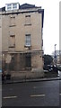
10
10 Fountain Buildings, Lansdown Road, Bath
A stately house of c1730-40, altered c1775, the jarring shopfront late C19th. The central bay projects slightly and has a rusticated ground floor, Venetian window and pediment. Moulded architraves to the upper windows. Grade II listed.
Now flats, the disastrous shop occupied by Stonier Hobbs, estate agents.
Image: © Stephen Richards
Taken: 25 May 2012
0.02 miles