IMAGES TAKEN NEAR TO
Prestbury Drive, WARMINSTER, BA12 9LF
Introduction
This page details the photographs taken nearby to Prestbury Drive, BA12 9LF by members of the Geograph project.
The Geograph project started in 2005 with the aim of publishing, organising and preserving representative images for every square kilometre of Great Britain, Ireland and the Isle of Man.

There are currently over 7.5m images from over14,400 individuals and you can help contribute to the project by visiting https://www.geograph.org.uk
Image Map
Images are licensed for reuse under creativecommons.org/licenses/by-sa/2.0
Notes
- Clicking on the map will re-center to the selected point.
- The higher the marker number, the further away the image location is from the centre of the postcode.
Image Listing (43 Images Found)
Images are licensed for reuse under creativecommons.org/licenses/by-sa/2.0
Image
Details
Distance
2
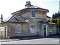
Holly Lodge, Boreham Road
The toll house was built by the Warminster Turnpike Trust in 1840 and is built of ashlar.
Image: © Maigheach-gheal
Taken: 14 Mar 2011
0.17 miles
3
Holly Lodge, Boreham Road
The toll house was built by the Warminster Turnpike Trust in 1840. There is an Ordnance Survey bench mark on the wall on the right hand side of the image.
Image: © Maigheach-gheal
Taken: 14 Mar 2011
0.17 miles
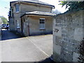
5
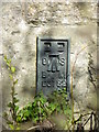
Flush bracket G3782, Warminster
The flush bracket is on the south face of No 95 Boreham Road. For a view of the house Image and for further information on the bracket and others in the area http://www.bench-marks.org.uk/bm12292
Image: © Maigheach-gheal
Taken: 14 Mar 2011
0.17 miles
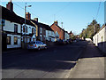
6
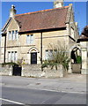
95 Boreham Road, Warminster
The house was built in 1871 of local stone. There is an Ordnance Survey flush bracket on the south west angle.
Image: © Maigheach-gheal
Taken: 14 Mar 2011
0.17 miles
7
St John the Evangelist, Boreham: porch memorial
Image: © Basher Eyre
Taken: 22 Aug 2016
0.17 miles
8
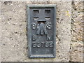
Ordnance Survey Flush Bracket G3782
This can be found on the wall of a building in Boreham Road, Warminster.
For more detail see : http://www.bench-marks.org.uk/bm12292
Image: © Peter Wood
Taken: 13 Feb 2017
0.18 miles
9
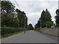
Looking east-southeast along Boreham Road
Image: © Basher Eyre
Taken: 22 Aug 2016
0.18 miles
10
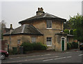
Old Toll House by the A36, Warminster
Boreham Road by the A36, in parish of Warminster (West Wiltshire District), Holly Lodge, No. 70, Boreham Road, BA12.
Grade II listed.
List Entry Number: 1036184 https://historicengland.org.uk/listing/the-list/list-entry/1036184
Surveyed
Milestone Society National ID: WI.WAR01
Image: © Alan Rosevear
Taken: 13 Oct 2007
0.18 miles