IMAGES TAKEN NEAR TO
Clay Street, WARMINSTER, BA12 8AJ
Introduction
This page details the photographs taken nearby to Clay Street, BA12 8AJ by members of the Geograph project.
The Geograph project started in 2005 with the aim of publishing, organising and preserving representative images for every square kilometre of Great Britain, Ireland and the Isle of Man.

There are currently over 7.5m images from over14,400 individuals and you can help contribute to the project by visiting https://www.geograph.org.uk
Image Map
Images are licensed for reuse under creativecommons.org/licenses/by-sa/2.0
Notes
- Clicking on the map will re-center to the selected point.
- The higher the marker number, the further away the image location is from the centre of the postcode.
Image Listing (16 Images Found)
Images are licensed for reuse under creativecommons.org/licenses/by-sa/2.0
Image
Details
Distance
1
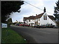
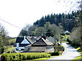
Clay Street
A view looking west along Clay Street showing the Bath Arms public house.
Image: © Phil Williams
Taken: 2 Apr 2006
0.02 miles
2
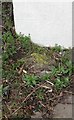
Old Milestone in Crockerton
Warminster plate by the UC road, in parish of Longbridge Deverill (West Wiltshire District), Crockerton; 20m North of junction with Clay Street, in front of bus shelter.
Inscription once read:-
(WARMINSTER 2)
(SHAFTESBURY 13)
May be the remains of:
Milestone Society National ID: WI_WMSH02
Image: © Milestone Society
Taken: Unknown
0.06 miles
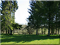
3
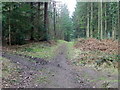
Junction, Foxholes Plantation
Junction of permissive paths within the woodland.
Image: © Maigheach-gheal
Taken: 2 Mar 2012
0.09 miles
4
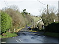
2008 : The old Warminster Road, Crockerton
Standing at the junction with Clay Street,the road to Maiden Bradley.
In front of us is the former A350 Warminster to Shaftesbury road.
Image: © Maurice Pullin
Taken: 19 Nov 2008
0.10 miles
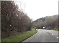
5
2010 : The former A350 at Crockerton
The main road between Warminster and Shaftesbury has been subject to straightening and improvement.
Image: © Maurice Pullin
Taken: 17 Apr 2010
0.12 miles
6
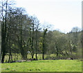
2010 : Pasture and well developed hedgerow, Crockerton
Looking west in the direction of Shear Water.
Image: © Maurice Pullin
Taken: 17 Apr 2010
0.13 miles
7
Crockerton shopping centre turning ahead
From A350
Image: © John Firth
Taken: 11 Apr 2013
0.14 miles
8
2010 : East from a minor road through Crockerton
Image: © Maurice Pullin
Taken: 17 Apr 2010
0.16 miles
9
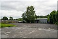
Longbridge Deverill : Crockerton - The Learning Meadow
A building off the A350.
Image: © Lewis Clarke
Taken: 31 Jul 2023
0.18 miles
10
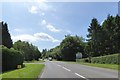
A350 bypassing Crockerton
The sign on the right points to a garden centre and linked businesses
Image: © David Smith
Taken: 1 Jun 2017
0.18 miles