IMAGES TAKEN NEAR TO
Campbell Place, Norton Road, WARMINSTER, BA12 7SA
Introduction
This page details the photographs taken nearby to Campbell Place, Norton Road, BA12 7SA by members of the Geograph project.
The Geograph project started in 2005 with the aim of publishing, organising and preserving representative images for every square kilometre of Great Britain, Ireland and the Isle of Man.

There are currently over 7.5m images from over14,400 individuals and you can help contribute to the project by visiting https://www.geograph.org.uk
Image Map
Images are licensed for reuse under creativecommons.org/licenses/by-sa/2.0
Notes
- Clicking on the map will re-center to the selected point.
- The higher the marker number, the further away the image location is from the centre of the postcode.
Image Listing (16 Images Found)
Images are licensed for reuse under creativecommons.org/licenses/by-sa/2.0
Image
Details
Distance
1
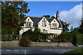
House opposite the end of Best's Lane, Sutton Veny
Image: © David Martin
Taken: 1 Oct 2018
0.04 miles
2
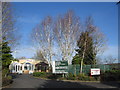
Pound Barton Trading Estate, Sutton Veny
A view looking north to the entrance to the Pound Barton trading estate at Sutton Veny.
Image: © Phil Williams
Taken: 21 Jan 2006
0.05 miles
3

Post box at the junction of Norton Road and Everett Close
Image: © Basher Eyre
Taken: 13 Sep 2013
0.06 miles
5

The Woolpack
Looks like the sad demise of yet another country pub. The sign has gone, a skip sits outside, workmen are inside - and the pub in Sutton Veny is closed.
Image: © Colin Smith
Taken: 25 Feb 2009
0.08 miles
6
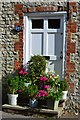
Mind the step!
Flowery doorstep in High Street, Sutton Veny.
Image: © David Martin
Taken: 1 Oct 2018
0.09 miles
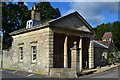
8

Old Direction Sign - Signpost by High Street, Sutton Veny
Pyramid top finial - 4 arms; Wilts. wooden by the UC road, in parish of Sutton Veny (West Wiltshire District), Sutton Veny, behind stone garden wall and hedge, village crossroads of High Street with Norton Road and Deverill Road.
Surveyed
Milestone Society National ID: WI_ST8942
Image: © Milestone Society
Taken: Unknown
0.10 miles
10

Greenhill Gardens, Sutton Veny
Substantial brick house in the centre of the village. It carries a crest which is common in the village, just below the roofline.
http://suttonveny.co.uk/index.html
Image: © Colin Smith
Taken: 25 Feb 2009
0.13 miles