IMAGES TAKEN NEAR TO
Corsley, WARMINSTER, BA12 7QU
Introduction
This page details the photographs taken nearby to BA12 7QU by members of the Geograph project.
The Geograph project started in 2005 with the aim of publishing, organising and preserving representative images for every square kilometre of Great Britain, Ireland and the Isle of Man.

There are currently over 7.5m images from over14,400 individuals and you can help contribute to the project by visiting https://www.geograph.org.uk
Image Map
Images are licensed for reuse under creativecommons.org/licenses/by-sa/2.0
Notes
- Clicking on the map will re-center to the selected point.
- The higher the marker number, the further away the image location is from the centre of the postcode.
Image Listing (10 Images Found)
Images are licensed for reuse under creativecommons.org/licenses/by-sa/2.0
Image
Details
Distance
1
View west from Cley Hill
Cley Hill is an isolated chalk outcrop.
Image: © Robin Webster
Taken: 2 Mar 2017
0.04 miles
2

2008 : Sturford Mead Farm
See http://www.stayatsturford.co.uk/index.php for accommodation. There is a footpath from the farm straight up Cley Hill if you fancy a run before breakfast.
Image: © Maurice Pullin
Taken: 21 Aug 2008
0.08 miles
3
The view West from the summit of Cley Hill
NOTE : check the "more sizes" option for a higher resolution version of this picture.
The view West from the summit of Cley Hill
Image: © Len Williams
Taken: 10 Jun 2011
0.08 miles
4

Sturford from Cley Hill
The prominent house in the centre is Sturford Mead.
Image: © David Martin
Taken: 25 Mar 2023
0.12 miles
5
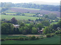
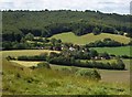
Sturford Mead from Cley Hill
Taken from the slopes of Cley Hill, with the A362 in the foreground.
The big house among the trees on the left is Sturford Mead, circa 1820, Grade II listed - https://www.historicengland.org.uk/listing/the-list/list-entry/1194491
In the middle distance is Temple hamlet in Corsley parish. Woodland in the far distance is part of the Longleat estate.
Image: © Steve Roberts
Taken: 12 May 2016
0.12 miles
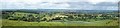
6
The village of Sturtford from Cley Hill
The village of Sturtford to the West of Cley Hill.
Image: © Len Williams
Taken: 10 Jun 2011
0.14 miles
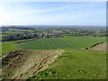
7
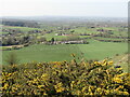
Sturford Mead Farm
Fieldscape to the west of Cley Hill. Pasture and hedgerows predominate.
Gorse in the foreground is in bloom.
Image: © Colin Smith
Taken: 26 Mar 2022
0.15 miles
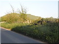
8
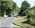
2010 : A362 heading south east toward Warminster
The minor road to the right is signed to Temple. The entrance to Whitbourne Farm is beyond.
Image: © Maurice Pullin
Taken: 28 Jun 2010
0.19 miles