IMAGES TAKEN NEAR TO
Lyes Green, WARMINSTER, BA12 7PB
Introduction
This page details the photographs taken nearby to Lyes Green, BA12 7PB by members of the Geograph project.
The Geograph project started in 2005 with the aim of publishing, organising and preserving representative images for every square kilometre of Great Britain, Ireland and the Isle of Man.

There are currently over 7.5m images from over14,400 individuals and you can help contribute to the project by visiting https://www.geograph.org.uk
Image Map
Images are licensed for reuse under creativecommons.org/licenses/by-sa/2.0
Notes
- Clicking on the map will re-center to the selected point.
- The higher the marker number, the further away the image location is from the centre of the postcode.
Image Listing (8 Images Found)
Images are licensed for reuse under creativecommons.org/licenses/by-sa/2.0
Image
Details
Distance
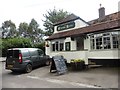
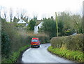
3
2009 : The Cross Keys, Lye's Green
Seen from the west, on the road from Corsley Heath.
Image: © Maurice Pullin
Taken: 13 Jan 2009
0.13 miles
4
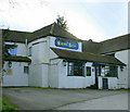
2009 : The Cross Keys, Lye's Green
Situated off the main road near Corsley Heath. http://www.gazetteandherald.co.uk/leisure/fooddrink/reviews/4014928.The_Cross_Keys___Corsley/
Image: © Maurice Pullin
Taken: 13 Jan 2009
0.14 miles
5
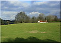
2009 : Pasture at Lye's Green
Near Corsley Heath.
Looking north, the field has only recently been vacated, the animals, probably cattle, having been taken in for the cold weather.
Image: © Maurice Pullin
Taken: 13 Jan 2009
0.14 miles
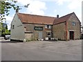
6
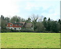
2009 : Pasture and house, Lye's Green
Near the Cross Keys looking toward Court Lane.
Image: © Maurice Pullin
Taken: 13 Jan 2009
0.16 miles
7
2009 : Lye's Green, looking toward Court Lane
http://www.wiltshire.gov.uk/community/getcom.php?id=72 has this and much more so say.
"The small parish of Corsley is situated on the Somerset border next to Longleat. It is quite unusual in that it has no village and no centre, only the distinct hamlets of Corsley, three Whitbournes, Longhedge, Corsley Heath, Lane End and Lyes Green, loosely connected by narrow lanes. The name is obscure, but probably comes from the Old British ‘Cors’ meaning reeds or a swamp. Apart from the chalk area around Cley Hill, most of the parish is on Upper Greensand. Two streams flowing west into Somerset trisect it."
Image: © Maurice Pullin
Taken: 13 Jan 2009
0.20 miles
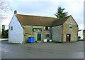
8
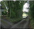
2009 : Blind lane at Lye's Green
Just a short lane leading south from the bus stop, only a few footpaths at the end.
Image: © Maurice Pullin
Taken: 13 Jan 2009
0.22 miles