IMAGES TAKEN NEAR TO
Newbury, WARMINSTER, BA12 7LG
Introduction
This page details the photographs taken nearby to Newbury, BA12 7LG by members of the Geograph project.
The Geograph project started in 2005 with the aim of publishing, organising and preserving representative images for every square kilometre of Great Britain, Ireland and the Isle of Man.

There are currently over 7.5m images from over14,400 individuals and you can help contribute to the project by visiting https://www.geograph.org.uk
Image Map
Images are licensed for reuse under creativecommons.org/licenses/by-sa/2.0
Notes
- Clicking on the map will re-center to the selected point.
- The higher the marker number, the further away the image location is from the centre of the postcode.
Image Listing (7 Images Found)
Images are licensed for reuse under creativecommons.org/licenses/by-sa/2.0
Image
Details
Distance
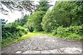
1
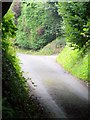
Lane, Horningsham
The tarmac lane soon turns into a track as it enters the woodland of Longleat Estate.
Image: © Maigheach-gheal
Taken: 10 Aug 2009
0.17 miles
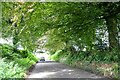
2
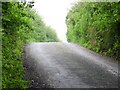
Lane, Horningsham
This narrow road soon turns into a bridleway track as it heads into the woodland of the Longleat Estate.
Image: © Maigheach-gheal
Taken: 10 Aug 2009
0.20 miles
3
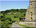
2009 : Horningsham Parish Church and view
"The parish church was founded in the 12th century. The only part surviving from the Middle Ages is the perpendicular tower, and even this has undergone some restoration."
The above was copied from: http://www.wiltshire.gov.uk/community/getcom.php?id=121
Image: © Maurice Pullin
Taken: 2 Jun 2009
0.22 miles
4
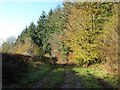
Bridleway and Mid Wilts Way
The Mid Wilts Way follows this bridleway leading to the village of Horningsham. The woodland on the right borders the parkland of Longleat House.
Image: © Philip Halling
Taken: 17 Nov 2017
0.23 miles
5
Horningham : Track
A track to Newbury.
Image: © Lewis Clarke
Taken: 28 Jul 2023
0.23 miles
7
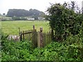
Kissing gate, Horningsham
The kissing gate gives access to the footpath that takes walkers to another part of the divided village of Horningham.
Image: © Maigheach-gheal
Taken: 10 Aug 2009
0.24 miles