IMAGES TAKEN NEAR TO
The Square, WARMINSTER, BA12 7JQ
Introduction
This page details the photographs taken nearby to The Square, BA12 7JQ by members of the Geograph project.
The Geograph project started in 2005 with the aim of publishing, organising and preserving representative images for every square kilometre of Great Britain, Ireland and the Isle of Man.

There are currently over 7.5m images from over14,400 individuals and you can help contribute to the project by visiting https://www.geograph.org.uk
Image Map
Images are licensed for reuse under creativecommons.org/licenses/by-sa/2.0
Notes
- Clicking on the map will re-center to the selected point.
- The higher the marker number, the further away the image location is from the centre of the postcode.
Image Listing (38 Images Found)
Images are licensed for reuse under creativecommons.org/licenses/by-sa/2.0
Image
Details
Distance
1
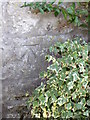
Bench Mark, The Corner House
The bench mark is to be found on the north west face of the building. For a view of the building Image and for further information on the bench mark and others in the area http://www.bench-marks.org.uk/bm37353
Image: © Maigheach-gheal
Taken: 19 Mar 2011
0.02 miles
2
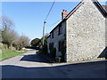
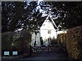
The Corner House, Maiden Bradley
The house stands beside the minor road as it enters the village. There is an Ordnance Survey bench mark on the north west face of the building.
Image: © Maigheach-gheal
Taken: 19 Mar 2011
0.04 miles
3
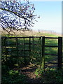
Kissing gate, Maiden Bradley
The kissing gate gives walkers access to the footpath that takes them to the B3092.
The kissing gate is a traditional gate hung in a U or V shape that allows one person to pass at a time. In order for one person to pass fully through the gate they have to close it on the next person. Legend has it that at this point, when the two are on either side of the gate, the person in front ‘refuses’ entry to the second person until presented with a kiss.
Image: © Maigheach-gheal
Taken: 19 Mar 2011
0.06 miles
4
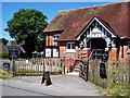
Village Memorial Hall
The village hall was built in 1912 and given to the village by Lord Ernest St Maur (Somerset family name) in memory of his brother Lord Percy. During the First World War it was used as a military hospital and has murals dating from that time. Since then the hall has been used for a variety of events. Village Hall Management Committee in association with Trustees meet every few months. Registered Charity No: 275599.
- Wikipedia https://en.wikipedia.org/wiki/Maiden_Bradley_with_Yarnfield#Early_Modern
( For full article visit Maiden Bradley Memorial Hall site - https://sites.google.com/site/mbvhall/ )
Image: © John Potts
Taken: 15 Jul 2013
0.08 miles
5
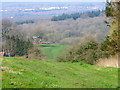
Footpath, Maiden Bradley
The footpath heads down hill to join the B3092, Frome Road. Frome can be seen in the far distance.
Image: © Maigheach-gheal
Taken: 19 Mar 2011
0.09 miles
6
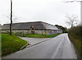
Perry Farmhouse
MAIDEN BRADLEY HIGH STREET ST 83 NW (south side) Perry Farmhouse Grade: II. Date first listed: 09-Sep-1987. Farmhouse. Circa 1700, altered C19. Rubble stone, rendered south front, triple ridge tiles to 2-span roof, gable end brick stacks. Two-storey, 3-window. Central 6-panelled door in Cl9 gabled stone porch with segmental-arched opening, C19 three-light ovolo- mullioned casement either side, lintel string course. First floor has 3-light original ovolo-mullioned casement either side of central 2-light. Attached to right is 2-storey range with 20-pane and 16-pane sashes. Left return has string courses to first floor and eaves level, C19 two-light ovolo-mullioned casements, several blocked openings to left hand range. Rear has 2-light casements and 2-light ovolo-mullioned casements, ovolo-moulded attic lights with hoodmoulds, one in left hand gable original. Right return has attached lean-to extension, 2-light original ovolo-mullioned casement to first floor. Interior not accessible at time of survey (October 1986). - English Heritage http://list.english-heritage.org.uk/resultsingle.aspx?uid=1198557
( For full article visit my Maiden Bradley Listed Buildings (etc) site - https://sites.google.com/site/maidenbradleylistedbuildings/listed/high-street )
Image: © John Potts
Taken: 5 Nov 2013
0.11 miles
7
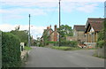
Maiden Bradley, converted farm
Once Perry Farm, now offices of NFU Mutual. http://www.nfumutual.co.uk/warminster/team.htm
Image: © Mike Faherty
Taken: 4 Nov 2011
0.13 miles
8
2008 : High Street, Maiden Bradley
The earliest known reference to the village occurs in a Saxon land charter of King Cyncwulf of Wessex, 878AD, but it was in existence centuries before as not only is it situated on the ancient track way between Exeter and Dover but the Roman road from Old Sarum to Uphill in the Mendips (where lead was mined) also passed through the village, while the existence of Iron age fortifications on the Little Knoll, and between it and the Long Knoll, indicates that there were people here two thousand or more years ago
The above text was copied from: http://www.btinternet.com/~JIM.DOWNES1/history.htm
Image: © Maurice Pullin
Taken: 22 Aug 2008
0.14 miles
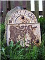
9

Old Milestone by High Street, Maiden Bradley
Metal plate attached to stone post by the UC road, in parish of MAIDEN BRADLEY WITH YARNFIELD (SALISBURY District), High Street, on shallow bank outside village hall, on North side of road. Bruton Sun iron plate, erected by the Bruton turnpike trust in the 18th century.
Inscription reads:-
BRUTON
8
Miles
Milestone Society National ID: WI_BNMB08.
Image: © M Faherty
Taken: 6 Mar 2007
0.15 miles
10
Milestone
'Bruton 8 Miles' - Milestone, High Street, Maiden Bradley (roadside next to Memorial Hall.
( For full article visit my Maiden Bradley Listed Buildings (etc) site - https://sites.google.com/site/maidenbradleylistedbuildings/z---Misc/milestone )
Image: © John Potts
Taken: 5 Nov 2013
0.15 miles