IMAGES TAKEN NEAR TO
Kingston Deverill, WARMINSTER, BA12 7HH
Introduction
This page details the photographs taken nearby to BA12 7HH by members of the Geograph project.
The Geograph project started in 2005 with the aim of publishing, organising and preserving representative images for every square kilometre of Great Britain, Ireland and the Isle of Man.

There are currently over 7.5m images from over14,400 individuals and you can help contribute to the project by visiting https://www.geograph.org.uk
Image Map
Images are licensed for reuse under creativecommons.org/licenses/by-sa/2.0
Notes
- Clicking on the map will re-center to the selected point.
- The higher the marker number, the further away the image location is from the centre of the postcode.
Image Listing (6 Images Found)
Images are licensed for reuse under creativecommons.org/licenses/by-sa/2.0
Image
Details
Distance
1
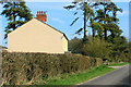
2012 : Dairy Farm from Kingston Lane
Similar to Image] taken in 2006. Not much has changed, probably not much changed in the last 50 years apart from the TV aerial, repainted recently, chimney stack seems to have been repointed.
Image: © Maurice Pullin
Taken: 23 Mar 2012
0.01 miles
2

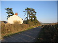
2012 : Large earth mover turns into a farm track
Opposite Dairy Farm.
Not nearly as near that red car as it looks (I'm pleased to say).
The road continues to Kingston Deverill. The hill opposite is on the other side of the valley, twin hedgerows mark the B3095 as it climbs out of Kingston Deverill on its way to Mere.
Image: © Maurice Pullin
Taken: 23 Mar 2012
0.02 miles
3
Dairy Farm
A view looking southeast towards the farmhouse at Dairy Farm.
Image: © Phil Williams
Taken: 19 Mar 2006
0.05 miles
4
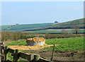
2012 : Cattle feeder near Dairy Farm
Will you look at all that lovely straw? Delicious, just coming up to its best. Go down a treat with a gallon or two out of the drinking trough, with some fresh grass for afters.
King's Hill with a barn atop is on the other side of Kingston Deverill.
Image: © Maurice Pullin
Taken: 23 Mar 2012
0.05 miles
5
2012 : Kingston Lane near Dairy Farm
Heading east to Kingston Deverill along the upper Wylye Valley.
The clump of trees on the hilltop is the end if a long plantation seen end on at the top of King's Hill.
Image: © Maurice Pullin
Taken: 23 Mar 2012
0.07 miles
6
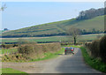
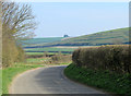
2012 : Minor road to Kingston Deverill
The eastern end of Court Hill is behind with King's Hill beyond that to the left.
Image: © Maurice Pullin
Taken: 23 Mar 2012
0.10 miles