IMAGES TAKEN NEAR TO
Kingston Deverill, WARMINSTER, BA12 7HF
Introduction
This page details the photographs taken nearby to BA12 7HF by members of the Geograph project.
The Geograph project started in 2005 with the aim of publishing, organising and preserving representative images for every square kilometre of Great Britain, Ireland and the Isle of Man.

There are currently over 7.5m images from over14,400 individuals and you can help contribute to the project by visiting https://www.geograph.org.uk
Image Map
Images are licensed for reuse under creativecommons.org/licenses/by-sa/2.0
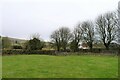
Notes
- Clicking on the map will re-center to the selected point.
- The higher the marker number, the further away the image location is from the centre of the postcode.
Image Listing (40 Images Found)
Images are licensed for reuse under creativecommons.org/licenses/by-sa/2.0
Image
Details
Distance
1
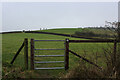
Footpath leading up to Court Hill
Through the gate, the undefined footpath leads diagonally through the pasture to reach the flanks of Court Hill.
Image: © Chris Heaton
Taken: 1 Feb 2022
0.06 miles
2
The Mid Wilts Way entering Kingston Deverill
Onto the narrow flood plain of the River Wylye after leaving Court Hill
Image: © Tim Heaton
Taken: 1 Feb 2022
0.06 miles
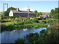
3
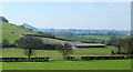
2012 :North of west from the B3095
Across the base of Court Hill and along the upper Wylye Valley. Little Knoll and Little Knoll Wood appears to the left.
Barns in foreground fields belong to Kingston Dairy.
Image: © Maurice Pullin
Taken: 23 Mar 2012
0.12 miles
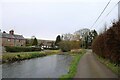
4
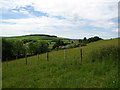
On the West Wiltshire Way
View following it's route south west through Kingston Deverill to Court Hill
Image: © Maggie Cox
Taken: 29 Jun 2013
0.12 miles
5
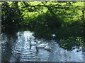
Waddling around the Wylye
Some feathered friends on the river in Kingston Deverill.
Image: © Neil Owen
Taken: 17 Jul 2020
0.17 miles
6
Ducks on the Wylye
The clear and unspoiled waters of the river are clearly helping the wildlife. Here it spreads out over a large shallow where habitats are more varied.
Image: © Neil Owen
Taken: 17 Jul 2020
0.17 miles
7
The River Wylye through Kingston Deverill
Image: © Tim Heaton
Taken: 1 Feb 2022
0.18 miles
8
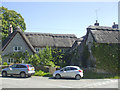
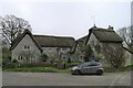
Kings Cottages
A couple of thatched houses in the village, one of which was the post office in the nineteenth century.
Image: © Neil Owen
Taken: 17 Jul 2020
0.20 miles
9
36 and 38 Kingston Deverill
Listed Grade II, 17th century semi-detached cottages https://historicengland.org.uk/listing/the-list/list-entry/1036399?section=official-listing
Image: © Tim Heaton
Taken: 1 Feb 2022
0.20 miles
10
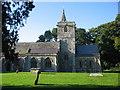
Kingston Deverill church
The church of St. Mary the Virgin, Kingston Deverill in the September evening sunshine.
Image: © Phil Williams
Taken: 9 Sep 2005
0.21 miles