IMAGES TAKEN NEAR TO
Swainsford, WARMINSTER, BA12 6JT
Introduction
This page details the photographs taken nearby to Swainsford, BA12 6JT by members of the Geograph project.
The Geograph project started in 2005 with the aim of publishing, organising and preserving representative images for every square kilometre of Great Britain, Ireland and the Isle of Man.

There are currently over 7.5m images from over14,400 individuals and you can help contribute to the project by visiting https://www.geograph.org.uk
Image Map
Images are licensed for reuse under creativecommons.org/licenses/by-sa/2.0
Notes
- Clicking on the map will re-center to the selected point.
- The higher the marker number, the further away the image location is from the centre of the postcode.
Image Listing (7 Images Found)
Images are licensed for reuse under creativecommons.org/licenses/by-sa/2.0
Image
Details
Distance
1
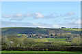
West Swainsford Farm and Broadwater Farm
Broadwater Farm has the large barn and white house to the right.
Image: © Robin Webster
Taken: 2 Apr 2017
0.01 miles

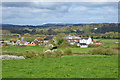
3
Wiltshire Cycleway
A view looking south along Woodlands Road towards the junction at which the Wiltshire Cycleway diverges to the right, as indicated by the small blue sign on the telegraph pole.
Image: © Phil Williams
Taken: 4 Aug 2006
0.21 miles
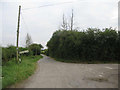
4
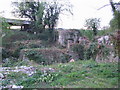
Hinks Mill
A view looking to the northwest towards the remains of the mill building at Hinks Mill. Shreen Water runs between the ivy-covered walls where the waterwheel once turned. This http://www.meremuseum.org.uk/galleries/hinksmillfarm.php has more information.
Image: © Phil Williams
Taken: 25 Apr 2007
0.21 miles
5
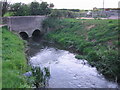
Bridge at Hinks Mill
A view looking to the southwest along Shreen Water towards the bridge at Hinks Mill.
Image: © Phil Williams
Taken: 25 Apr 2007
0.22 miles
6
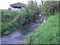
Shreen Water at Hinks Mill
A view looking to the northeast, upstream along Shreen Water at Hinks Mill.
Image: © Phil Williams
Taken: 25 Apr 2007
0.23 miles