IMAGES TAKEN NEAR TO
Boyton, WARMINSTER, BA12 0ST
Introduction
This page details the photographs taken nearby to BA12 0ST by members of the Geograph project.
The Geograph project started in 2005 with the aim of publishing, organising and preserving representative images for every square kilometre of Great Britain, Ireland and the Isle of Man.

There are currently over 7.5m images from over14,400 individuals and you can help contribute to the project by visiting https://www.geograph.org.uk
Image Map
Images are licensed for reuse under creativecommons.org/licenses/by-sa/2.0
Notes
- Clicking on the map will re-center to the selected point.
- The higher the marker number, the further away the image location is from the centre of the postcode.
Image Listing (12 Images Found)
Images are licensed for reuse under creativecommons.org/licenses/by-sa/2.0
Image
Details
Distance
1
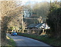
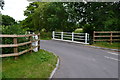
2011 : Minor road from Corton
Heading south east near Suffers Bridge to Boyton, one mile, and Sherrington, two miles.
Image: © Maurice Pullin
Taken: 7 Mar 2011
0.03 miles
2
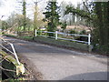
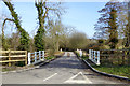
Suffers Bridge
A view looking to the east across Suffers Bridge carrying Water Street over the River Wylye.
Image: © Phil Williams
Taken: 4 Feb 2007
0.08 miles
3
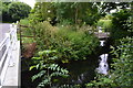
Bridges and weir in the Wylye Valley near Upton Lovell
Image: © David Martin
Taken: 7 Jul 2016
0.08 miles
4
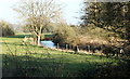
2011 : River Wylye south of Upton Lovell
East of Corton.
Crosses the valley north to south between the two villages.
Image: © Maurice Pullin
Taken: 7 Mar 2011
0.09 miles
6
Water Street bridges the River Wylye
The river has two strands here. These look more likely over this stretch to be for land drainage purposes rather than for supplying any water mill.
Image: © Robin Webster
Taken: 2 Mar 2017
0.09 miles
7

2011 : Minor road leaving Boyton
Next Corton then Tytherington.
A pleasant unhurried drive along the Wylye Valley.
Even better on your bike.
Image: © Maurice Pullin
Taken: 5 Aug 2011
0.11 miles
8
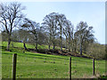
Beech trees, Wylye Valley
The steep slope they are growing on is probably where harder chalk overlies the chalk marl of the valley floor. There once was a small quarry a bit further to the right along the slope.
Image: © Robin Webster
Taken: 2 Mar 2017
0.14 miles
9
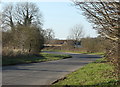
2011 : On the road to Corton
About half a mile, heading west near Suffers Bridge.
Image: © Maurice Pullin
Taken: 7 Mar 2011
0.16 miles
10
2011 : Scene in the Wylye Valley
Looking toward Corton from Suffers Bridge.
The river is beyond the fence on the other side of this field. A small river but with sufficient force to power grist mills all along the valley.
Image: © Maurice Pullin
Taken: 7 Mar 2011
0.22 miles