IMAGES TAKEN NEAR TO
Townsend, WARMINSTER, BA12 0RY
Introduction
This page details the photographs taken nearby to Townsend, BA12 0RY by members of the Geograph project.
The Geograph project started in 2005 with the aim of publishing, organising and preserving representative images for every square kilometre of Great Britain, Ireland and the Isle of Man.

There are currently over 7.5m images from over14,400 individuals and you can help contribute to the project by visiting https://www.geograph.org.uk
Image Map
Images are licensed for reuse under creativecommons.org/licenses/by-sa/2.0
Notes
- Clicking on the map will re-center to the selected point.
- The higher the marker number, the further away the image location is from the centre of the postcode.
Image Listing (113 Images Found)
Images are licensed for reuse under creativecommons.org/licenses/by-sa/2.0
Image
Details
Distance
1
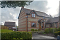
Wyle : Townsend Cottage
A house on Townsend.
Image: © Lewis Clarke
Taken: 29 Mar 2018
0.01 miles
2
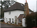
Old Toll House by Town's End, Wylye
Wylye Toll House by the UC road (was A303), in parish of Wylye (Salisbury District), Toll Cottage, Town's End, BA12 0RZ.
Surveyed
Milestone Society National ID: WI.WYL
Image: © Alan Rosevear
Taken: Unknown
0.06 miles
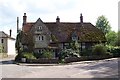
4
Cottage on Dyer Lane
Strikingly square thatched cottage on the main road through Wylye village.
Image: © Colin Smith
Taken: 25 Feb 2009
0.09 miles
5
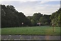
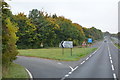
Salisbury District : The A303 Roadside
The roadside and junction off the A303 near Wylye.
Image: © Lewis Clarke
Taken: 23 Aug 2012
0.13 miles
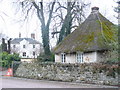
7
![Wylye houses [10]](https://s2.geograph.org.uk/geophotos/07/18/55/7185514_6c426804_120x120.jpg)
Wylye houses [10]
Wylye Place, Dyer Lane, is a former Rectory, now a private dwelling. Built in the early 19th century and constructed of stuccoed flint and limestone under a Welsh slate hipped roof, brick stacks. Many original features and fittings remain. Listed, grade II, with details at: https://historicengland.org.uk/listing/the-list/list-entry/1183367
The village of Wylye is located halfway between Salisbury and Warminster, some 9½ miles (15 kilometres) from both. The village is astride the River Wylye and is just south of the major road intersection with the junction of the A36 and the A303. Within the wider area Bronze Age artefacts have been found, there is an Iron Age hill fort and a Roman Road runs east to west.
Image: © Michael Dibb
Taken: 20 Apr 2022
0.14 miles
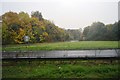
9
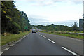
A303 heading west
Crossing the Wylye Valley.
Image: © Robin Webster
Taken: 7 Sep 2019
0.14 miles
10
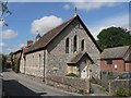
Wylye: The Chapel
This little chapel, named simply The Chapel, is at the eastern end of Teapot Street.
Image: © Chris Downer
Taken: 27 Aug 2007
0.16 miles