IMAGES TAKEN NEAR TO
Millers Close, WARMINSTER, BA12 0RA
Introduction
This page details the photographs taken nearby to Millers Close, BA12 0RA by members of the Geograph project.
The Geograph project started in 2005 with the aim of publishing, organising and preserving representative images for every square kilometre of Great Britain, Ireland and the Isle of Man.

There are currently over 7.5m images from over14,400 individuals and you can help contribute to the project by visiting https://www.geograph.org.uk
Image Map
Images are licensed for reuse under creativecommons.org/licenses/by-sa/2.0
Notes
- Clicking on the map will re-center to the selected point.
- The higher the marker number, the further away the image location is from the centre of the postcode.
Image Listing (131 Images Found)
Images are licensed for reuse under creativecommons.org/licenses/by-sa/2.0
Image
Details
Distance
1
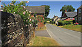
Dinton Road, Wylye
With the turning into the cul-de-sac of Millers Close on the left.
Image: © Derek Harper
Taken: 30 Jun 2018
0.01 miles
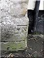
2

Minor road, Wylye
The minor road runs through the Wylye valley. There is an Ordnance Survey bench mark on the angle of the brick wall.
Image: © Maigheach-gheal
Taken: 16 Mar 2011
0.02 miles

4
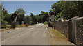
Level crossing, Wylye
On Dinton Road as it climbs out of the village towards the downs.
Image: © Derek Harper
Taken: 30 Jun 2018
0.03 miles
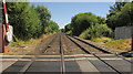
5

Level crossing, Wylye
Image: © Derek Harper
Taken: 30 Jun 2018
0.03 miles
6
![Wylye features [1]](https://s1.geograph.org.uk/geophotos/07/18/43/7184361_da6213ee_120x120.jpg)
Wylye features [1]
Dinton Road is crossed by the Salisbury branch line. The Great Western Railway line runs from Westbury to Salisbury as part of the Wessex Main Line.
The village of Wylye is located halfway between Salisbury and Warminster, some 9½ miles (15 kilometres) from both. The village is astride the River Wylye and is just south of the major road intersection with the junction of the A36 and the A303. Within the wider area Bronze Age artefacts have been found, there is an Iron Age hill fort and a Roman Road runs east to west.
Image: © Michael Dibb
Taken: 20 Apr 2022
0.03 miles
7
Bench Mark, East Farm
The bench mark is to be found on the north west angle of the farm building. For a view of the wall Image and for further information on the bench mark and others in the area http://www.bench-marks.org.uk/bm37317
Image: © Maigheach-gheal
Taken: 16 Mar 2011
0.04 miles
8
Level crossing, Wylye
Looking in the opposite direction to Image The lines run straight for over two kilometres here.
Image: © Derek Harper
Taken: 30 Jun 2018
0.06 miles
9
![Wylye houses [4]](https://s2.geograph.org.uk/geophotos/07/18/43/7184366_fd4bba0f_120x120.jpg)
Wylye houses [4]
Walnut Cottage, Fore Street, is a late 17th century detached cottage. There is a 19th century rear extension. Constructed of chequered flint and limestone under a thatch roof. Listed, grade II, with details at: https://historicengland.org.uk/listing/the-list/list-entry/1146211
The village of Wylye is located halfway between Salisbury and Warminster, some 9½ miles (15 kilometres) from both. The village is astride the River Wylye and is just south of the major road intersection with the junction of the A36 and the A303. Within the wider area Bronze Age artefacts have been found, there is an Iron Age hill fort and a Roman Road runs east to west.
Image: © Michael Dibb
Taken: 20 Apr 2022
0.06 miles
10
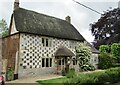
Wylye - Thatched Cottage
Eye catching historic thatched cottage with chequerboard stonework.
Image: © Colin Smith
Taken: 14 Jun 2019
0.07 miles