IMAGES TAKEN NEAR TO
High Street, WARMINSTER, BA12 0QW
Introduction
This page details the photographs taken nearby to High Street, BA12 0QW by members of the Geograph project.
The Geograph project started in 2005 with the aim of publishing, organising and preserving representative images for every square kilometre of Great Britain, Ireland and the Isle of Man.

There are currently over 7.5m images from over14,400 individuals and you can help contribute to the project by visiting https://www.geograph.org.uk
Image Map
Images are licensed for reuse under creativecommons.org/licenses/by-sa/2.0
Notes
- Clicking on the map will re-center to the selected point.
- The higher the marker number, the further away the image location is from the centre of the postcode.
Image Listing (138 Images Found)
Images are licensed for reuse under creativecommons.org/licenses/by-sa/2.0
Image
Details
Distance
1
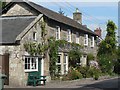
Wylye: cottages
Image: © Chris Downer
Taken: 27 Aug 2007
0.01 miles

3
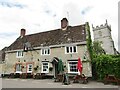
Wylye - The Bell
Village pub with a common position - next to the village church.
Image: © Colin Smith
Taken: 14 Jun 2019
0.02 miles
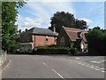
4
![Wylye houses [11]](https://s1.geograph.org.uk/geophotos/07/19/23/7192357_94fd2c33_120x120.jpg)
Wylye houses [11]
The Lodge, Dyer Lane, is a detached cottage built in the early 19th century with later alterations. Constructed of cob on rubble stone footings under a thatch roof. Listed, grade II, with details at: https://historicengland.org.uk/listing/the-list/list-entry/1318728
The village of Wylye is located halfway between Salisbury and Warminster, some 9½ miles (15 kilometres) from both. The village is astride the River Wylye and is just south of the major road intersection with the junction of the A36 and the A303. Within the wider area Bronze Age artefacts have been found, there is an Iron Age hill fort and a Roman Road runs east to west.
Image: © Michael Dibb
Taken: 20 Apr 2022
0.03 miles
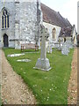
6
![Parish church [5]](https://s1.geograph.org.uk/geophotos/07/18/43/7184353_b7f0db62_120x120.jpg)
Parish church [5]
At the south edge of the churchyard is this railed enclosure and a pair of gate piers. The enclosure is 18th century with a limestone ashlar wall with fine cast and wrought-iron railings with scrolled panels and twisted corner posts. The stone gate piers attached to the enclosure are probably 18th century. Listed, grade II, with details at: https://historicengland.org.uk/listing/the-list/list-entry/1183311
The Anglican parish church of St Mary, was rebuilt in 1846 with only the tower and the walls of the chancel retained from the earlier building. The chancel is 13th century, the tower 15th century. Constructed of squared, coursed limestone and flint under a tile roof. Listed, grade II*, with details at: https://historicengland.org.uk/listing/the-list/list-entry/1146203
The village of Wyle is located halfway between Salisbury and Warminster, some 9½ miles (15 kilometres) from both. The village is astride the River Wylye and is just south of the major road intersection with the junction of the A36 and the A303. Within the wider area Bronze Age artefacts have been found, there is an Iron Age hill fort and a Roman Road runs east to west.
Image: © Michael Dibb
Taken: 20 Apr 2022
0.03 miles
7

NEW
Wylye - Popjay memorial
This fine enclosure of wrought and cast iron railings is against the southern perimeter of Image
Oddly it seems that there is no tomb within its bounds, nor any visible dedication - the story of this anomaly is said to be as follows:
In the C18th a local man by the name of Popjay was transported to Australia for unspecified crimes. Years later he returned to Wylye having made a fortune. He lodged at Image] and asked after his mother and sister. Sadly he discovered that both had died during his banishment and had been lain to rest in a pauper's grave. He ordered that this fine tomb should be erected and his late family should be reburied there. However, when the work was to be paid for, Popjay had disappeared never to be seen again. The rector of St Mary's had to make good the cost of it.
This story was recounted by antiquarian Richard Colt Hoare of Stourhead House and there is little to corroborate the veracity of it.
However, apparently in 1840 the Rev Francis Baker chose to be buried within its precincts although there is still no noticeable dedication nor tomb within its confines.
The monument dates from the C18th and is EH Grade II listed: https://historicengland.org.uk/listing/the-list/list-entry/1183311?section=official-list-entry
Image: © Rob Farrow
Taken: 11 Mar 2025
0.03 miles
8
War memorial
Wylye war memorial is located in the churchyard of the church of St Mary. The memorial is a granite wheel-head cross upon a tall shaft with moulded foot. This rises from a tapering, four-sided plinth, on a square base. Listed, grade II, with details at: https://historicengland.org.uk/listing/the-list/list-entry/1451934
The village of Wyle is located halfway between Salisbury and Warminster, some 9½ miles (15 kilometres) from both. The village is astride the River Wylye and is just south of the major road intersection with the junction of the A36 and the A303. Within the wider area Bronze Age artefacts have been found, there is an Iron Age hill fort and a Roman Road runs east to west.
Image: © Michael Dibb
Taken: 20 Apr 2022
0.03 miles
10

NEW
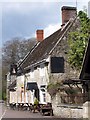
Wylye - The Bell Inn
The Bell Inn in the village of Wylye dates (according to English Heritage) from the late C17th - however a small plaque attached to it claims that it dates back to the C14th. It serves several real ales including at least one from their own "nano-brewery" (I had a pint of Moonraker) - I can recommend the food too.
The pub's own website: https://bellinnwylye.co.uk
The brewery's website: https://bellinnwylye.co.uk/wylyebrew
EH Grade II listing : https://historicengland.org.uk/listing/the-list/list-entry/1198009?section=official-list-entry
Image: © Rob Farrow
Taken: 11 Mar 2025
0.03 miles