IMAGES TAKEN NEAR TO
High Street, WARMINSTER, BA12 0QP
Introduction
This page details the photographs taken nearby to High Street, BA12 0QP by members of the Geograph project.
The Geograph project started in 2005 with the aim of publishing, organising and preserving representative images for every square kilometre of Great Britain, Ireland and the Isle of Man.

There are currently over 7.5m images from over14,400 individuals and you can help contribute to the project by visiting https://www.geograph.org.uk
Image Map
Images are licensed for reuse under creativecommons.org/licenses/by-sa/2.0
Notes
- Clicking on the map will re-center to the selected point.
- The higher the marker number, the further away the image location is from the centre of the postcode.
Image Listing (139 Images Found)
Images are licensed for reuse under creativecommons.org/licenses/by-sa/2.0
Image
Details
Distance
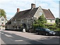
1
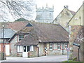
Wyvern Hall
Approaching the quiet village of Wylye from the bridge. Old stone houses abound.
http://www.ukvillages.co.uk/village/wylye-wiltshire
Image: © Colin Smith
Taken: 25 Feb 2009
0.01 miles
2
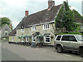
The Bell Inn, Wylye
A building constructed in the late 17th C. It has 19th C extensions (see http://www.britishlistedbuildings.co.uk/en-320569-the-bell-inn-wylye).
Image: © Stuart Logan
Taken: 26 Jul 2011
0.01 miles
4
The Bell Inn by the Church
Village Pub by the Church.
Image: © roger geach
Taken: 1 Jul 2010
0.02 miles
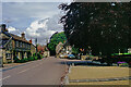
5
Wylye: Bell Inn
This pub is next door to the parish church.
Image: © Chris Downer
Taken: 27 Aug 2007
0.02 miles
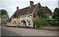
6
![Wylye houses [14]](https://s0.geograph.org.uk/geophotos/07/19/23/7192364_9c4ffdda_120x120.jpg)
Wylye houses [14]
Perrior House, High Street, was originally built in the 17th century and rebuilt in the late 18th century. Set gable end to the street and constructed of rubble stone and chalk, partly rendered, under a tile roof. There is a late 19th century lean-to extension at the rear and some 19th century cast-iron railings at the front. Listed, grade II, with details at: https://historicengland.org.uk/listing/the-list/list-entry/1198013
The village of Wylye is located halfway between Salisbury and Warminster, some 9½ miles (15 kilometres) from both. The village is astride the River Wylye and is just south of the major road intersection with the junction of the A36 and the A303. Within the wider area Bronze Age artefacts have been found, there is an Iron Age hill fort and a Roman Road runs east to west.
Image: © Michael Dibb
Taken: 20 Apr 2022
0.02 miles

8
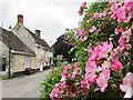
Wylye - High Street
Village main street with colourful display of flowers and the Bell pub.
Image: © Colin Smith
Taken: 14 Jun 2019
0.02 miles
9
![Wylye buildings [1]](https://s1.geograph.org.uk/geophotos/07/19/23/7192361_1467ae2d_120x120.jpg)
Wylye buildings [1]
The Bell Inn, High Street, was built in the late 17th century and extended at the rear in the 19th century. Constructed partly in rubble stone and partly in dressed limestone, all under a tile roof. Listed, grade II, with details at: https://historicengland.org.uk/listing/the-list/list-entry/1198009
The village of Wylye is located halfway between Salisbury and Warminster, some 9½ miles (15 kilometres) from both. The village is astride the River Wylye and is just south of the major road intersection with the junction of the A36 and the A303. Within the wider area Bronze Age artefacts have been found, there is an Iron Age hill fort and a Roman Road runs east to west.
Image: © Michael Dibb
Taken: 20 Apr 2022
0.02 miles
10
![Wylye houses [13]](https://s3.geograph.org.uk/geophotos/07/19/23/7192363_52859bbd_120x120.jpg)
Wylye houses [13]
Down House, High Street, is a late 17th century detached house with a mid 18th century rear wing and late 20th century alterations. Constructed, in an 'L' plan, of dressed limestone under a tile roof. Some 17th century internal features remain. Listed, grade II, with details at: https://historicengland.org.uk/listing/the-list/list-entry/1146213
The village of Wylye is located halfway between Salisbury and Warminster, some 9½ miles (15 kilometres) from both. The village is astride the River Wylye and is just south of the major road intersection with the junction of the A36 and the A303. Within the wider area Bronze Age artefacts have been found, there is an Iron Age hill fort and a Roman Road runs east to west.
Image: © Michael Dibb
Taken: 20 Apr 2022
0.03 miles