IMAGES TAKEN NEAR TO
Wylye, WARMINSTER, BA12 0QF
Introduction
This page details the photographs taken nearby to BA12 0QF by members of the Geograph project.
The Geograph project started in 2005 with the aim of publishing, organising and preserving representative images for every square kilometre of Great Britain, Ireland and the Isle of Man.

There are currently over 7.5m images from over14,400 individuals and you can help contribute to the project by visiting https://www.geograph.org.uk
Image Map
Images are licensed for reuse under creativecommons.org/licenses/by-sa/2.0
Notes
- Clicking on the map will re-center to the selected point.
- The higher the marker number, the further away the image location is from the centre of the postcode.
Image Listing (5 Images Found)
Images are licensed for reuse under creativecommons.org/licenses/by-sa/2.0
Image
Details
Distance
1
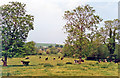
Wylye Valley from A36 road east of Wylye, 1994
View southward, near Ballington: unspoilt English countryside.
Image: © Ben Brooksbank
Taken: 1 Jun 1994
0.15 miles

3
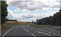
A36 towards Steeple Langford
The road runs parallel to the Wylye River.
Image: © Julian P Guffogg
Taken: 12 Aug 2013
0.17 miles
4
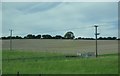
Salisbury District : Countryside & Telegraph Poles
Looking out towards the open countryside from the A36.
Image: © Lewis Clarke
Taken: 28 Aug 2012
0.23 miles
5
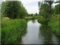
The River Wylye
Looking upstream from the footbridge on the footpath near Ballington Manor, where it crosses the northern of the river's two channels.
Image: © Andrew Smith
Taken: 23 Jun 2007
0.24 miles