IMAGES TAKEN NEAR TO
Upton Lovell, WARMINSTER, BA12 0JR
Introduction
This page details the photographs taken nearby to BA12 0JR by members of the Geograph project.
The Geograph project started in 2005 with the aim of publishing, organising and preserving representative images for every square kilometre of Great Britain, Ireland and the Isle of Man.

There are currently over 7.5m images from over14,400 individuals and you can help contribute to the project by visiting https://www.geograph.org.uk
Image Map
Images are licensed for reuse under creativecommons.org/licenses/by-sa/2.0
Notes
- Clicking on the map will re-center to the selected point.
- The higher the marker number, the further away the image location is from the centre of the postcode.
Image Listing (13 Images Found)
Images are licensed for reuse under creativecommons.org/licenses/by-sa/2.0
Image
Details
Distance
1
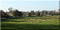
2011 : Scene in the Wylye Valley
Looking toward Corton from Suffers Bridge.
The river is beyond the fence on the other side of this field. A small river but with sufficient force to power grist mills all along the valley.
Image: © Maurice Pullin
Taken: 7 Mar 2011
0.12 miles
2
Upton Lovell, Wiltshire
Looking east along the railway track to the south of the village of Upton Lovell.
Image: © Rebecca A Wills
Taken: 27 Dec 2020
0.15 miles
3
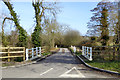
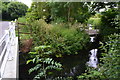
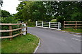
Water Street bridges the River Wylye
The river has two strands here. These look more likely over this stretch to be for land drainage purposes rather than for supplying any water mill.
Image: © Robin Webster
Taken: 2 Mar 2017
0.15 miles
4
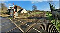
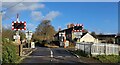
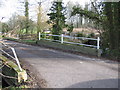
Water street level crossing
A view looking to the northeast along Water street towards the level crossing at Upton Lovell.
Image: © Phil Williams
Taken: 4 Feb 2007
0.15 miles
5
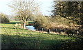
Bridges and weir in the Wylye Valley near Upton Lovell
Image: © David Martin
Taken: 7 Jul 2016
0.15 miles
6
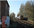
2011 : Train from Warminster approaching Upton Lovell crossing
Seen from the Water Street level crossing on the line through the Wylye Valley to Salisbury.
Image: © Maurice Pullin
Taken: 7 Mar 2011
0.15 miles
7
2011 : River Wylye south of Upton Lovell
East of Corton.
Crosses the valley north to south between the two villages.
Image: © Maurice Pullin
Taken: 7 Mar 2011
0.15 miles
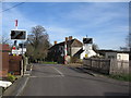
8
Upton Lovell, Wiltshire
The level crossing to the south of the village of Upton Lovell.
Image: © Rebecca A Wills
Taken: 27 Dec 2020
0.16 miles
10
Suffers Bridge
A view looking to the east across Suffers Bridge carrying Water Street over the River Wylye.
Image: © Phil Williams
Taken: 4 Feb 2007
0.16 miles