IMAGES TAKEN NEAR TO
Chitterne Anstey, WARMINSTER, BA12 0JA
Introduction
This page details the photographs taken nearby to BA12 0JA by members of the Geograph project.
The Geograph project started in 2005 with the aim of publishing, organising and preserving representative images for every square kilometre of Great Britain, Ireland and the Isle of Man.

There are currently over 7.5m images from over14,400 individuals and you can help contribute to the project by visiting https://www.geograph.org.uk
Image Map
Images are licensed for reuse under creativecommons.org/licenses/by-sa/2.0
Notes
- Clicking on the map will re-center to the selected point.
- The higher the marker number, the further away the image location is from the centre of the postcode.
Image Listing (8 Images Found)
Images are licensed for reuse under creativecommons.org/licenses/by-sa/2.0
Image
Details
Distance
1
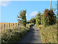
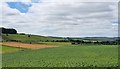
2011 : Climbing the track from the B390 to Knook Down House
Then on over Knook Down to the Military Range.
A good crop of hawthorn berries or haws this year.
Image: © Maurice Pullin
Taken: 18 Oct 2011
0.11 miles
2
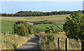
2011 : Not far from the bottom, track and bridleway from Knook Down
A turn to the right then on to the B390.
A chalk pit appears on the other side of the valley, dug out by farmers to improve the soil.
Image: © Maurice Pullin
Taken: 18 Oct 2011
0.14 miles
3
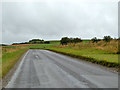
B390 west of Chitterne
Heading towards Heytesbury.
Image: © Robin Webster
Taken: 21 Aug 2016
0.17 miles
4
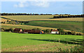
2011 : Field at the foot of Knook Down
With Flower's Field Barn in the background, and winding up Ansty Hill in the distance, the B390.
Image: © Maurice Pullin
Taken: 18 Oct 2011
0.17 miles
5
Knook Down, Wiltshire
Looking from Knook Down in the direction of the village of Knook.
Image: © Rebecca A Wills
Taken: 18 Jul 2020
0.20 miles
6
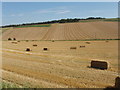
Harvested fields
In the foreground the wheat straw has been collected into rectangular bales. The field beyond has rows of cut hay ready to be baled. The woods on the skyline are around Upton Barrow.
Image: © David Hawgood
Taken: 25 Aug 2007
0.20 miles
7
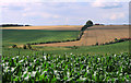
2011 : Field of maize and a dry valley east of Heytesbury
On the edge of Salisbury Plain.
The track on the far side leads up to Willis's Field Barn at the top of the hill.
Image: © Maurice Pullin
Taken: 5 Aug 2011
0.23 miles
8
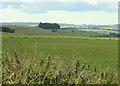
2009 : Knook Down from Quebec Farm
Can't tell what is being grown is this field, the next one over is almost certainly maize.
Image: © Maurice Pullin
Taken: 25 Jul 2009
0.24 miles