IMAGES TAKEN NEAR TO
Heytesbury, WARMINSTER, BA12 0HP
Introduction
This page details the photographs taken nearby to BA12 0HP by members of the Geograph project.
The Geograph project started in 2005 with the aim of publishing, organising and preserving representative images for every square kilometre of Great Britain, Ireland and the Isle of Man.

There are currently over 7.5m images from over14,400 individuals and you can help contribute to the project by visiting https://www.geograph.org.uk
Image Map
Images are licensed for reuse under creativecommons.org/licenses/by-sa/2.0
Notes
- Clicking on the map will re-center to the selected point.
- The higher the marker number, the further away the image location is from the centre of the postcode.
Image Listing (6 Images Found)
Images are licensed for reuse under creativecommons.org/licenses/by-sa/2.0
Image
Details
Distance
1
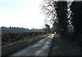
2011 : The Imber Range Perimeter Path
The lane left the military range about half a mile behind the camera position, but this is still the perimeter path.
Image: © Maurice Pullin
Taken: 30 Jan 2011
0.11 miles
2
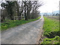
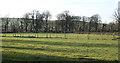
Imber Range Perimeter Path
A view looking to the southwest along the Imber Range Perimeter Path, which at this point follows the lane to East Hill Farm. The white railing marks the culvert where a tributary of the River Wylye passes diagonally under the lane. Cotley Hill Wood can be seen on the skyline at right.
Image: © Phil Williams
Taken: 1 Apr 2007
0.12 miles
3
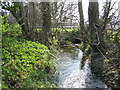
Tributary of the River Wylye
A view looking to the southeast along a small tributary of the River Wylye. The white railings in the background marks the culvert where the stream passes under the Imber Range Perimeter Path.
Image: © Phil Williams
Taken: 1 Apr 2007
0.13 miles
4
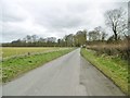
Heytesbury, minor road
Climbing gently from A36; giving access to two farms and the Military Training Area. This section of road also forms part of the Imber Range Perimeter Path.
Image: © Mike Faherty
Taken: 1 Apr 2018
0.14 miles
5
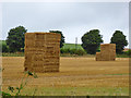
Straw bales, Heytesbury
West of the Imber road.
Image: © Robin Webster
Taken: 21 Aug 2016
0.19 miles
6
2011 : West from the Imber Range Perimeter Path
The perimeter path does not follow the range boundary at this point.
Image: © Maurice Pullin
Taken: 30 Jan 2011
0.19 miles