IMAGES TAKEN NEAR TO
Victoria Gardens, WARMINSTER, BA12 0HB
Introduction
This page details the photographs taken nearby to Victoria Gardens, BA12 0HB by members of the Geograph project.
The Geograph project started in 2005 with the aim of publishing, organising and preserving representative images for every square kilometre of Great Britain, Ireland and the Isle of Man.

There are currently over 7.5m images from over14,400 individuals and you can help contribute to the project by visiting https://www.geograph.org.uk
Image Map
Images are licensed for reuse under creativecommons.org/licenses/by-sa/2.0
Notes
- Clicking on the map will re-center to the selected point.
- The higher the marker number, the further away the image location is from the centre of the postcode.
Image Listing (92 Images Found)
Images are licensed for reuse under creativecommons.org/licenses/by-sa/2.0
Image
Details
Distance
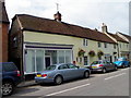
1
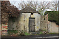
Former Village Lock Up, Heytesbury
This curious little building on High Street was once the village lock-up, where local drunks could be left to sober up.
Passed by the Wessex Ridgeway long distance footpath.
Image: © Chris Heaton
Taken: 12 Feb 2020
0.02 miles
2
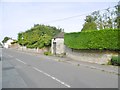
Heytesbury, blind house
Former village lock-up on High Street; C18, listed by Historic England: http://www.imagesofengland.org.uk/Details/Default.aspx?id=313272&mode=adv
Image: © Mike Faherty
Taken: 26 Aug 2017
0.02 miles
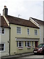
3
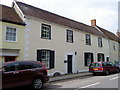
Quebec House, Heytesbury
Late 18th century house on the High Street.
Image: © Maigheach-gheal
Taken: 24 Jul 2011
0.03 miles
4
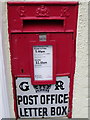
Postbox, Heytesbury
A George V reign postbox set into the wall of the Resting Post Image
Image: © Maigheach-gheal
Taken: 24 Jul 2011
0.03 miles
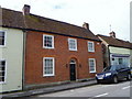
5
The Resting Post, Heytesbury
Late 18th century former shop and post office now a bed and breakfast establishment.
Image: © Maigheach-gheal
Taken: 24 Jul 2011
0.03 miles
6

York House, Heytesbury
Late 18th century house on the High Street.
Image: © Maigheach-gheal
Taken: 24 Jul 2011
0.03 miles
7
65 The High Street
Late 18th century shop now a house.
Image: © Maigheach-gheal
Taken: 24 Jul 2011
0.04 miles
8
68 The High Street, Heytesbury
Early 19th century brick built house.
Image: © Maigheach-gheal
Taken: 24 Jul 2011
0.04 miles
9
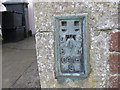
Ordnance Survey Flush Bracket S0416
This can be found on the roadside wall of a house in High Street, Heytesbury.
For more detail see : http://www.bench-marks.org.uk/bm15634
Image: © Peter Wood
Taken: 13 Feb 2017
0.05 miles
10

No 73 The High Street, Heytesbury
There is an Ordnance Survey flush bracket on the north east angle of this late 18th century building (green shutters).
Image: © Maigheach-gheal
Taken: 24 Jul 2011
0.05 miles