IMAGES TAKEN NEAR TO
Rudge Lane, FROME, BA11 6TS
Introduction
This page details the photographs taken nearby to Rudge Lane, BA11 6TS by members of the Geograph project.
The Geograph project started in 2005 with the aim of publishing, organising and preserving representative images for every square kilometre of Great Britain, Ireland and the Isle of Man.

There are currently over 7.5m images from over14,400 individuals and you can help contribute to the project by visiting https://www.geograph.org.uk
Image Map
Images are licensed for reuse under creativecommons.org/licenses/by-sa/2.0
Notes
- Clicking on the map will re-center to the selected point.
- The higher the marker number, the further away the image location is from the centre of the postcode.
Image Listing (6 Images Found)
Images are licensed for reuse under creativecommons.org/licenses/by-sa/2.0
Image
Details
Distance
1
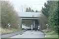
2008 : The road to Rudge
Somewhere along here Goose Street turns into Rudge Lane.
The bridge carries the A36, part of the great Wiltshire bypass as it makes its way past Beckington, Frome, Westbury and Warminster.
Image: © Maurice Pullin
Taken: 5 Jan 2008
0.13 miles
2
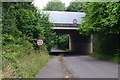
Bridge carrying the A36 over Rudge Lane
Image: © David Martin
Taken: 7 Jul 2016
0.14 miles
3

The A36 goes over Goose Street
Goose Street is now ended by the overbridge; beyond it becomes Rudge Lane.
Image: © Neil Owen
Taken: 22 Mar 2021
0.14 miles
4
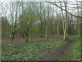
Path through the sound barriers
When the bypass was built in 1989, a narrow strip of land beside the A36 was planted with trees to help with the reduction of road noise. A footpath goes through it.
Image: © Neil Owen
Taken: 22 Mar 2021
0.16 miles
5
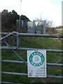
Watching the power
An electricity sub-station is part of the field, part of the surveillance.
Image: © Neil Owen
Taken: 22 Mar 2021
0.19 miles
6

2008 : Riders on Goose Street
A little further back (behind the camera) Goose Street becomes Rudge Lane and reaches Rudge itself about 2 miles away.
Image: © Maurice Pullin
Taken: 5 Jan 2008
0.25 miles