IMAGES TAKEN NEAR TO
Lower Street, FROME, BA11 6PU
Introduction
This page details the photographs taken nearby to Lower Street, BA11 6PU by members of the Geograph project.
The Geograph project started in 2005 with the aim of publishing, organising and preserving representative images for every square kilometre of Great Britain, Ireland and the Isle of Man.

There are currently over 7.5m images from over14,400 individuals and you can help contribute to the project by visiting https://www.geograph.org.uk
Image Map
Images are licensed for reuse under creativecommons.org/licenses/by-sa/2.0
Notes
- Clicking on the map will re-center to the selected point.
- The higher the marker number, the further away the image location is from the centre of the postcode.
Image Listing (72 Images Found)
Images are licensed for reuse under creativecommons.org/licenses/by-sa/2.0
Image
Details
Distance
1
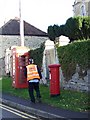
Telephone box and postbox, Rode
A K6 type telephone box and a George VI reign postbox on the High Street.
Image: © Maigheach-gheal
Taken: 17 Nov 2009
0.03 miles
2
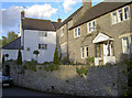
Homes on Lower Street
Rode has a range of styles and shapes along its streets. Look carefully at the walling behind the parked car and there is an enclosed feature hiding a water pump - see Image] for a close look.
Image: © Neil Owen
Taken: 4 Nov 2016
0.05 miles
3
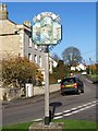
Village sign, Rode
Rode history is based on cloth mills and Fussels Brewery.
Image: © Maigheach-gheal
Taken: 17 Nov 2009
0.05 miles
4
The Old Schoolroom
The rise of Baptism in the area brought a number of changes - not least the establishment of a schoolroom in 1839. It is now a private residence.
Image: © Neil Owen
Taken: 7 Nov 2016
0.05 miles
6
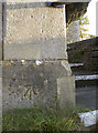
Benchmark on the chapel entrance
Rode's oldest Baptist chapel, with a benchmark. See http://www.bench-marks.org.uk/bm80277 for the entry in the Benchmark Database and Image] for a wider view.
Image: © Neil Owen
Taken: 7 Nov 2016
0.05 miles
7
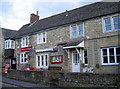
Rode Post Office
Opened in the early twentieth century and now one of very few village shops still in business.
Image: © Neil Owen
Taken: 4 Nov 2016
0.06 miles
8

Water in a cell
This water pump is situated in its own little walled enclosure and with a gate to keep unwelcome drinkers out. See Image] for a wider view of it set into the wall of a row of cottaged in Lower Street.
Image: © Neil Owen
Taken: 4 Nov 2016
0.06 miles
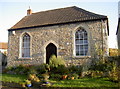
9
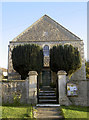
Rode Baptist Chapel
One of the village's oldest churches, it was founded in 1786. A benchmark can be found on the left of the entrance gate - see Image
Image: © Neil Owen
Taken: 7 Nov 2016
0.06 miles
10

2008 : Rode Village Sign
The sign is a celebration of the village past and present.
The left hand panel represents the wool industry which was the source of prosperity for the village during the 16th and 17th centuries with 4 or 5 woollen mills also the making of Queen Charlotte's dress and the invention of the dye "royal blue" at that time.
The right hand panel shows the brewing industry which unfortunately ceased in the 1960's.
The centre panel appears to represent the village today with the River Frome and its wildlife.
If anyone has more information or wishes to correct the above please contact the photographer. Also see http://en.wikipedia.org/wiki/Rode
Image: © Maurice Pullin
Taken: 5 Jan 2008
0.06 miles