IMAGES TAKEN NEAR TO
Wool Close, FROME, BA11 6AQ
Introduction
This page details the photographs taken nearby to Wool Close, BA11 6AQ by members of the Geograph project.
The Geograph project started in 2005 with the aim of publishing, organising and preserving representative images for every square kilometre of Great Britain, Ireland and the Isle of Man.

There are currently over 7.5m images from over14,400 individuals and you can help contribute to the project by visiting https://www.geograph.org.uk
Image Map
Images are licensed for reuse under creativecommons.org/licenses/by-sa/2.0
Notes
- Clicking on the map will re-center to the selected point.
- The higher the marker number, the further away the image location is from the centre of the postcode.
Image Listing (23 Images Found)
Images are licensed for reuse under creativecommons.org/licenses/by-sa/2.0
Image
Details
Distance
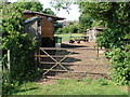
1
Path through the sound barriers
When the bypass was built in 1989, a narrow strip of land beside the A36 was planted with trees to help with the reduction of road noise. A footpath goes through it.
Image: © Neil Owen
Taken: 22 Mar 2021
0.05 miles
2
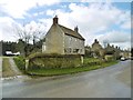
Beckington, Somerlea
Late C18 house on Warminster Road; listed by Historic England (Grade II): http://www.imagesofengland.org.uk/Details/Default.aspx?id=267049&mode=adv
Image: © Mike Faherty
Taken: 15 Mar 2018
0.10 miles
3

Beckington, De Cheney Gardens
New housing development on Warminster Road.
Image: © Mike Faherty
Taken: 15 Mar 2018
0.10 miles
4

Post down
The footpath signpost lies stricken; on it is a notice warning that removal of it carries a £1,000 fine.
Image: © Neil Owen
Taken: 22 Mar 2021
0.11 miles
5
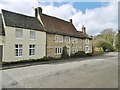
Beckington, Weavers Cottage
C17 cottage on Warminster Road; listed by Historic England (Grade II): http://www.imagesofengland.org.uk/Details/Default.aspx?id=267046&mode=adv
Image: © Mike Faherty
Taken: 15 Mar 2018
0.13 miles
6
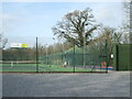
Beckington tennis courts
A couple of all-weather courts and a smaller facility.
Image: © Neil Owen
Taken: 22 Mar 2021
0.16 miles
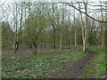
7
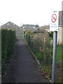
Cycling prohibited
A pathway in Beckington is subject to local Mendip District Council regulations.
Image: © Neil Owen
Taken: 22 Mar 2021
0.17 miles
8

The A36 goes over Goose Street
Goose Street is now ended by the overbridge; beyond it becomes Rudge Lane.
Image: © Neil Owen
Taken: 22 Mar 2021
0.17 miles
9
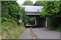
Bridge carrying the A36 over Rudge Lane
Image: © David Martin
Taken: 7 Jul 2016
0.17 miles