IMAGES TAKEN NEAR TO
Friggle Street, FROME, BA11 5LR
Introduction
This page details the photographs taken nearby to BA11 5LR by members of the Geograph project.
The Geograph project started in 2005 with the aim of publishing, organising and preserving representative images for every square kilometre of Great Britain, Ireland and the Isle of Man.

There are currently over 7.5m images from over14,400 individuals and you can help contribute to the project by visiting https://www.geograph.org.uk
Image Map (Loading...)


Getting Data...Please wait
Leaflet Map data © OpenStreetMap
Images are licensed for reuse under creativecommons.org/licenses/by-sa/2.0
Notes
- Clicking on the map will re-center to the selected point.
- The higher the marker number, the further away the image location is from the centre of the postcode.
Image Listing (6 Images Found)
Images are licensed for reuse under creativecommons.org/licenses/by-sa/2.0
Image
Details
Distance
1
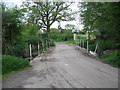
Ford on Mill Lane
A view looking to the southwest along Mill Lane towards the rather dry ford over Redford Water.
Image: © Phil Williams
Taken: 7 May 2006
0.10 miles
2
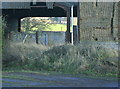
2009 : View through at Elliots Farm
The view through the barn proved too much of a temptation.
Image: © Maurice Pullin
Taken: 13 Jan 2009
0.12 miles
3
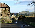
2009 : Well stocked barn at Elliots Farm
The cattle at Elliots Farm won't be going short this winter.
Cley Hill dominates the background. Image
Image: © Maurice Pullin
Taken: 13 Jan 2009
0.13 miles
4
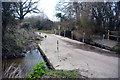
Dertfords Ford
This irish bridge ford on Redford Water is found on Mill Lane at Dertfords.
Image: © John Walton
Taken: 18 Mar 2016
0.17 miles
5
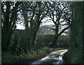
2009 : Mill Lane
A few yards round the next corner we see Image
The ford there has been put through a low culvert under the road which only becomes a ford when the water is high enough.
Image: © Maurice Pullin
Taken: 13 Jan 2009
0.21 miles
6
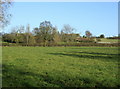
2009 : East from Mill Lane
Looking over quiet pastures near Redford Water.
Image: © Maurice Pullin
Taken: 13 Jan 2009
0.25 miles