IMAGES TAKEN NEAR TO
Rodden, FROME, BA11 5LD
Introduction
This page details the photographs taken nearby to BA11 5LD by members of the Geograph project.
The Geograph project started in 2005 with the aim of publishing, organising and preserving representative images for every square kilometre of Great Britain, Ireland and the Isle of Man.

There are currently over 7.5m images from over14,400 individuals and you can help contribute to the project by visiting https://www.geograph.org.uk
Image Map
Images are licensed for reuse under creativecommons.org/licenses/by-sa/2.0
Notes
- Clicking on the map will re-center to the selected point.
- The higher the marker number, the further away the image location is from the centre of the postcode.
Image Listing (3 Images Found)
Images are licensed for reuse under creativecommons.org/licenses/by-sa/2.0
Image
Details
Distance
2
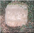
Old Milestone by the A362, Selwood parish
Metal plate attached to stone post by the A362, in parish of SELWOOD (MENDIP District), between Frome and Lane End, on grass verge beside gateway, on North side of road. Frome square iron plate, erected by the Frome turnpike trust in the 18th century.
Inscription reads:-
FROME
2
WARMINSTER
5
Somerset HER.
HER number: 37720 https://www.heritagegateway.org.uk/Gateway/Results_Single.aspx?uid=37720&resourceID=100
Milestone Society National ID: SO_FRWM02.
Image: © JR Dowding
Taken: 12 Jan 2003
0.13 miles
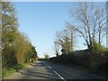
3
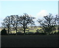
2009 : Ploughed field and oak trees near Woodcock Farm
The A362 runs between the farm buildings and the camera position.
Looking north east, Chapmanslade is on the far side of the hill seen through the trees.
Image: © Maurice Pullin
Taken: 13 Jan 2009
0.24 miles