IMAGES TAKEN NEAR TO
Styles Meadow, FROME, BA11 5JT
Introduction
This page details the photographs taken nearby to Styles Meadow, BA11 5JT by members of the Geograph project.
The Geograph project started in 2005 with the aim of publishing, organising and preserving representative images for every square kilometre of Great Britain, Ireland and the Isle of Man.

There are currently over 7.5m images from over14,400 individuals and you can help contribute to the project by visiting https://www.geograph.org.uk
Image Map (Loading...)


Getting Data...Please wait
Leaflet Map data © OpenStreetMap
Images are licensed for reuse under creativecommons.org/licenses/by-sa/2.0
Notes
- Clicking on the map will re-center to the selected point.
- The higher the marker number, the further away the image location is from the centre of the postcode.
Image Listing (14 Images Found)
Images are licensed for reuse under creativecommons.org/licenses/by-sa/2.0
Image
Details
Distance
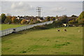
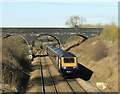
1
Styles Hill
Diverted Cross Country train deep in the cutting at Styles Hill, near Frome.
Image: © Wayland Smith
Taken: 23 Mar 2008
0.05 miles
3
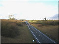
A361 Frome By-pass
A view looking north along the A361 Frome By-pass from the overbridge carrying the A3098 from Chapmanslade.
Image: © Phil Williams
Taken: 14 Jan 2006
0.10 miles
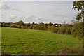
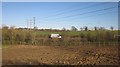
4
Waste Land Rodden Lake Stream
This small piece of land at the side of the railway is almost completely surrounded with built up land. It is too marshy for Building. Photo taken from a Yeovil to Bristol train.
Image: © Nigel Mykura
Taken: 6 Apr 2011
0.14 miles
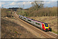
5
2010 : A First Direct HST heading south near Frome
On the Frome rail bypass approaching the footbridge at the end of Styles Avenue having passed through Westbury. Next Bruton.
Image: © Maurice Pullin
Taken: 8 Mar 2010
0.14 miles
6

Frome Avoiding Line
Footbridge on the Frome avoiding railway line.
Image: © Wayland Smith
Taken: 15 Sep 2007
0.14 miles
7
A361 near Frome
A stretch of A road running parallel to the main railway line between Taunton and Westbury as it avoids the loop into Frome station. The small rectangular field in between, shown as pasture on satellite images, has been dug up for something or other.
Image: © Derek Harper
Taken: 19 Mar 2012
0.15 miles
8

Old Milestone by the A3098, Styles Hill, Easthill, Frome
Metal plate attached to stone post by the A3098, in parish of SELWOOD (MENDIP District), Styles Hill, Easthill, East side of Frome, on grass verge, on South side of road. Frome square iron plate, erected by the Frome turnpike trust in the 18th century.
Inscription reads:-
Frome
1
Westbury
6
Grade II listed.
List Entry Number: 1058899 https://historicengland.org.uk/listing/the-list/list-entry/1058899
Milestone Society National ID: SO_FRWY01.
Image: © JR Dowding
Taken: 2 Mar 2009
0.16 miles