IMAGES TAKEN NEAR TO
Styles Close, FROME, BA11 5JS
Introduction
This page details the photographs taken nearby to Styles Close, BA11 5JS by members of the Geograph project.
The Geograph project started in 2005 with the aim of publishing, organising and preserving representative images for every square kilometre of Great Britain, Ireland and the Isle of Man.

There are currently over 7.5m images from over14,400 individuals and you can help contribute to the project by visiting https://www.geograph.org.uk
Image Map (Loading...)


Getting Data...Please wait
Leaflet Map data © OpenStreetMap
Images are licensed for reuse under creativecommons.org/licenses/by-sa/2.0
Notes
- Clicking on the map will re-center to the selected point.
- The higher the marker number, the further away the image location is from the centre of the postcode.
Image Listing (58 Images Found)
Images are licensed for reuse under creativecommons.org/licenses/by-sa/2.0
Image
Details
Distance
1

Old Milestone by the A3098, Styles Hill, Easthill, Frome
Metal plate attached to stone post by the A3098, in parish of SELWOOD (MENDIP District), Styles Hill, Easthill, East side of Frome, on grass verge, on South side of road. Frome square iron plate, erected by the Frome turnpike trust in the 18th century.
Inscription reads:-
Frome
1
Westbury
6
Grade II listed.
List Entry Number: 1058899 https://historicengland.org.uk/listing/the-list/list-entry/1058899
Milestone Society National ID: SO_FRWY01.
Image: © JR Dowding
Taken: 2 Mar 2009
0.07 miles
2
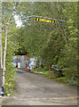
Squeezing under the bar
Someone must have wanted to avoid going the long way round.
Image: © Neil Owen
Taken: 13 May 2014
0.07 miles
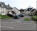
3
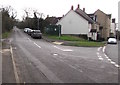
Southeast end of Rodden Road, Frome
From the New Road junction along Rodden Road towards the A3098 Styles Hill.
Image: © Jaggery
Taken: 11 Mar 2017
0.07 miles
4
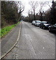
Rodden Road, Frome
From New Road along Rodden Road towards the A3098 Styles Hill.
Image: © Jaggery
Taken: 11 Mar 2017
0.07 miles
5
Rodden Road power
A large electricity station tucked away on the outskirts of town.
Image: © Neil Owen
Taken: 13 May 2014
0.08 miles
6
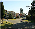
2010 : Modern housing off the A3098
To the south of Wallbridge.
A pleasant modern housing development like others in the town.
Handy for road and rail transport.
Image: © Maurice Pullin
Taken: 8 Mar 2010
0.09 miles
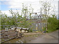
7
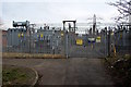
West side of a large electricity substation in Frome
Set back from Rodden Road near the New Road junction, the electricity substation occupies a site
measuring about 80 metres by 80 metres. Its identifier is Frome 33KV (33 kilovolts).
Image: © Jaggery
Taken: 11 Mar 2017
0.10 miles
8
Hillside Drive, Frome
Cul-de-sac on the east side of New Road.
Image: © Jaggery
Taken: 11 Mar 2017
0.11 miles
9
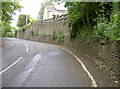
Styles Hill
The view up the A3098, from the junction with the A362 at Wallbridge - otherwise called Styles Hill. There is a stone set into the wall here, which has a curious inscription. See Image] for details.
Image: © Neil Owen
Taken: 13 May 2014
0.11 miles
10
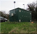
Wales & West Utilities gas installation on a Frome corner
On the Rodden Road side of the New Road corner.
Image: © Jaggery
Taken: 11 Mar 2017
0.11 miles