IMAGES TAKEN NEAR TO
Styles Avenue, FROME, BA11 5JN
Introduction
This page details the photographs taken nearby to Styles Avenue, BA11 5JN by members of the Geograph project.
The Geograph project started in 2005 with the aim of publishing, organising and preserving representative images for every square kilometre of Great Britain, Ireland and the Isle of Man.

There are currently over 7.5m images from over14,400 individuals and you can help contribute to the project by visiting https://www.geograph.org.uk
Image Map (Loading...)


Getting Data...Please wait
Leaflet Map data © OpenStreetMap
Images are licensed for reuse under creativecommons.org/licenses/by-sa/2.0
Notes
- Clicking on the map will re-center to the selected point.
- The higher the marker number, the further away the image location is from the centre of the postcode.
Image Listing (31 Images Found)
Images are licensed for reuse under creativecommons.org/licenses/by-sa/2.0
Image
Details
Distance
1

Frome Avoiding Line
Footbridge on the Frome avoiding railway line.
Image: © Wayland Smith
Taken: 15 Sep 2007
0.05 miles
2
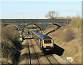
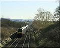
2010 : A First Direct HST heading south near Frome
On the Frome rail bypass approaching the footbridge at the end of Styles Avenue having passed through Westbury. Next Bruton.
Image: © Maurice Pullin
Taken: 8 Mar 2010
0.06 miles
3
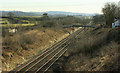
2010 : On the Frome rail bypass
The main line between Bristol and Weymouth, though there are branches to other places, Bournemouth, Exeter, Paddington etc.
This is seen from the A3098.
Look out for pictures taken from the footbridge.
Image: © Maurice Pullin
Taken: 8 Mar 2010
0.07 miles
4
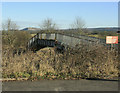
2010 : Footbridge over the main rail line near Frome
At the end of Styles Avenue.
Geograph is a website with history in mind, this bridge could be history at any time. Went onto it for a few pictures, not without trepidation.
More calming is Cley Hill, background left Image
Image: © Maurice Pullin
Taken: 8 Mar 2010
0.07 miles
5
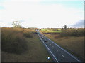
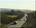
A361 Frome By-pass
A view looking north along the A361 Frome By-pass from the overbridge carrying the A3098 from Chapmanslade.
Image: © Phil Williams
Taken: 14 Jan 2006
0.07 miles
6

Old Milestone by the A3098, Styles Hill, Easthill, Frome
Metal plate attached to stone post by the A3098, in parish of SELWOOD (MENDIP District), Styles Hill, Easthill, East side of Frome, on grass verge, on South side of road. Frome square iron plate, erected by the Frome turnpike trust in the 18th century.
Inscription reads:-
Frome
1
Westbury
6
Grade II listed.
List Entry Number: 1058899 https://historicengland.org.uk/listing/the-list/list-entry/1058899
Milestone Society National ID: SO_FRWY01.
Image: © JR Dowding
Taken: 2 Mar 2009
0.08 miles
7
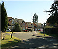
2010 : Modern housing off the A3098
To the south of Wallbridge.
A pleasant modern housing development like others in the town.
Handy for road and rail transport.
Image: © Maurice Pullin
Taken: 8 Mar 2010
0.08 miles
8
2010 : One of the Frome bypasses
Frome is blessed with two bypasses, one road and one rail, not bad for a town of that size.
Having passed under the footbridge seen in Image] a first direct HST heads south, probably to Weymouth but there are alternatives.
On the distant horizon in direct line with the tracks we see Alfred's Tower Image
Image: © Maurice Pullin
Taken: 8 Mar 2010
0.13 miles
9
2010 : A361 Frome bypass heading south west
Not long ago the A361 passed through the centre of Frome, now it has its own bypass, much to the relief of travellers and dwellers.
Further west the next place of any note is Shepton Mallet. It ends its journey at Ilfracombe.
Image: © Maurice Pullin
Taken: 8 Mar 2010
0.14 miles
10
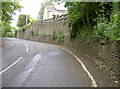
Styles Hill
The view up the A3098, from the junction with the A362 at Wallbridge - otherwise called Styles Hill. There is a stone set into the wall here, which has a curious inscription. See Image] for details.
Image: © Neil Owen
Taken: 13 May 2014
0.16 miles