IMAGES TAKEN NEAR TO
Rooks Lane, FROME, BA11 5JD
Introduction
This page details the photographs taken nearby to Rooks Lane, BA11 5JD by members of the Geograph project.
The Geograph project started in 2005 with the aim of publishing, organising and preserving representative images for every square kilometre of Great Britain, Ireland and the Isle of Man.

There are currently over 7.5m images from over14,400 individuals and you can help contribute to the project by visiting https://www.geograph.org.uk
Image Map (Loading...)


Getting Data...Please wait
Leaflet Map data © OpenStreetMap
Images are licensed for reuse under creativecommons.org/licenses/by-sa/2.0
Notes
- Clicking on the map will re-center to the selected point.
- The higher the marker number, the further away the image location is from the centre of the postcode.
Image Listing (3 Images Found)
Images are licensed for reuse under creativecommons.org/licenses/by-sa/2.0
Image
Details
Distance
1
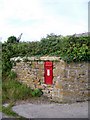
Postbox. Berkley Marsh
A George V reign postbox set into a wall at Fairoak Farm.
Image: © Maigheach-gheal
Taken: 21 Sep 2009
0.22 miles
2
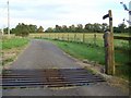
Footpath, Berkley Marsh
The footpath takes walkers from Fairoak Farm to the village of Berkley.
Image: © Maigheach-gheal
Taken: 21 Sep 2009
0.23 miles