IMAGES TAKEN NEAR TO
BA11 5GD
Introduction
This page details the photographs taken nearby to BA11 5GD by members of the Geograph project.
The Geograph project started in 2005 with the aim of publishing, organising and preserving representative images for every square kilometre of Great Britain, Ireland and the Isle of Man.

There are currently over 7.5m images from over14,400 individuals and you can help contribute to the project by visiting https://www.geograph.org.uk
Image Map (Loading...)


Getting Data...Please wait
Leaflet Map data © OpenStreetMap
Images are licensed for reuse under creativecommons.org/licenses/by-sa/2.0
Notes
- Clicking on the map will re-center to the selected point.
- The higher the marker number, the further away the image location is from the centre of the postcode.
Image Listing (9 Images Found)
Images are licensed for reuse under creativecommons.org/licenses/by-sa/2.0
Image
Details
Distance
1
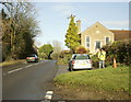
2008 : B3092 Frome to Maiden Bradley
At the end of Birchill Lane.
Image: © Maurice Pullin
Taken: 9 Dec 2008
0.08 miles
2

Old Milestone, B3092, South of Keyford
The milestone is located north of Claybatch Farm, buried in the hedge and embedded in the wall, on the west side of the road. Parish of Selwood (Mendip District). Metal plate attached to stone post, Frome square iron plate design, erected by the Frome turnpike trust in the 18th century.
Inscription reads:-
Frome / 1 / Longleat / 3 / M Bradley / 5
Somerset HER listed, HER number: 14591 https://www.heritagegateway.org.uk/Gateway/Results_Single.aspx?uid=14591&resourceID=100
Milestone Society National ID: SO_FRBR03
Image: © JR Dowding
Taken: 12 Jan 2003
0.09 miles
3
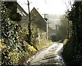
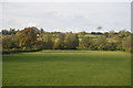
2008 : Lane near Little Keyford
Like Bath, Sheffield and Rome, Frome was built on hills. This one slopes away to the south.
Cottages : smoke
Image: © Maurice Pullin
Taken: 9 Dec 2008
0.10 miles
4
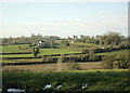
2008 : South of east from Birchill Lane
With Cley Hill centre frame, Corsley Heath is to the right of it almost competing for elevation.
Image
Image: © Maurice Pullin
Taken: 9 Dec 2008
0.14 miles
5

Blatchbridge
A view looking north along the B3092 to Blatchbridge, over the River Frome.
Image: © Phil Williams
Taken: 26 Feb 2006
0.22 miles
8
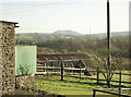
2008 : Near Claybatch Farm, Frome
Looking south west to Sandy's Hill Farm.
Image: © Maurice Pullin
Taken: 9 Dec 2008
0.24 miles
9
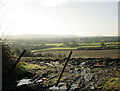
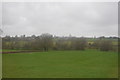
2008 : View from Little Keyford Lane
Looking south, Long Knoll is almost lost in the mist on the horizon near centre.
Image
Image: © Maurice Pullin
Taken: 9 Dec 2008
0.25 miles