IMAGES TAKEN NEAR TO
Reedmace Road, FROME, BA11 5FN
Introduction
This page details the photographs taken nearby to Reedmace Road, BA11 5FN by members of the Geograph project.
The Geograph project started in 2005 with the aim of publishing, organising and preserving representative images for every square kilometre of Great Britain, Ireland and the Isle of Man.

There are currently over 7.5m images from over14,400 individuals and you can help contribute to the project by visiting https://www.geograph.org.uk
Image Map (Loading...)


Getting Data...Please wait
Leaflet Map data © OpenStreetMap
Images are licensed for reuse under creativecommons.org/licenses/by-sa/2.0
Notes
- Clicking on the map will re-center to the selected point.
- The higher the marker number, the further away the image location is from the centre of the postcode.
Image Listing (4 Images Found)
Images are licensed for reuse under creativecommons.org/licenses/by-sa/2.0
Image
Details
Distance


4

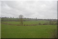
2008 : Entre deux railways
Between two railways.
The one on the right is the main line between London and the south west, on the left is the loop line through Frome station. Unfortunately they are both out of shot.
The pasture contains two oak trees and some electricity power lines.
Image: © Maurice Pullin
Taken: 9 Dec 2008
0.22 miles