IMAGES TAKEN NEAR TO
Millards Hill, FROME, BA11 5DW
Introduction
This page details the photographs taken nearby to Millards Hill, BA11 5DW by members of the Geograph project.
The Geograph project started in 2005 with the aim of publishing, organising and preserving representative images for every square kilometre of Great Britain, Ireland and the Isle of Man.

There are currently over 7.5m images from over14,400 individuals and you can help contribute to the project by visiting https://www.geograph.org.uk
Image Map (Loading...)


Getting Data...Please wait
Leaflet Map data © OpenStreetMap
Images are licensed for reuse under creativecommons.org/licenses/by-sa/2.0
Notes
- Clicking on the map will re-center to the selected point.
- The higher the marker number, the further away the image location is from the centre of the postcode.
Image Listing (7 Images Found)
Images are licensed for reuse under creativecommons.org/licenses/by-sa/2.0
Image
Details
Distance
1
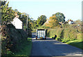
2010 : Minor road entering Trudoxhill
About to pass Cricket Farm on the right.
Image: © Maurice Pullin
Taken: 25 Oct 2010
0.03 miles
2
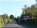
2010 : Looking south on the minor road out of Trudoxhill
Image: © Maurice Pullin
Taken: 25 Oct 2010
0.05 miles
3
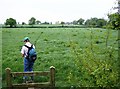
Towards Nutty Coppice Farm
The footpath across unused pasture appears obvious enough, but we'll check the map anyway. Nutty Coppice Farm at the southern boundary of the square is on the horizon.
Image: © Graham Horn
Taken: 4 May 2007
0.14 miles
4
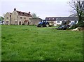
Nutty Coppice Farm
The stone farmhouse looks relatively new. Being on a slight rise, it has a fine view northwards (left) towards Trudoxhill and Frome.
Image: © Graham Horn
Taken: 4 May 2007
0.21 miles
5

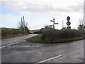
Direction Sign - Signpost at Nutty Coppice Farm, Trudoxhill
Pyramid finial - 3 arms; Somerset SCC pyramid by the UC road, in parish of Trudoxhill (Mendip District), at Nutty Coppice Farm, on the south side of the Y junction of roads to Withan Friary and Gare Hill.
surveyed
Milestone Society National ID: SO_ST7542A
Image: © Milestone Society
Taken: Unknown
0.23 miles
6
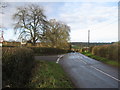
Approaching Lawns Farm
A view looking to the southeast across the road junction towards Lawns Farm. The Macmillan Way footpath leaves the metalled road at a gap in the hedge opposite the telegraph pole to the left of the centre of the image.
Image: © Phil Williams
Taken: 14 Jan 2007
0.25 miles
7
On the Macmillan Way
A view looking to the north along the Macmillan way footpath, which at this point traverses a short length of metalled lane, before heading north over farmland at Nutty Coppice Farm.
Image: © Phil Williams
Taken: 14 Jan 2007
0.25 miles