IMAGES TAKEN NEAR TO
Trudoxhill, FROME, BA11 5DS
Introduction
This page details the photographs taken nearby to BA11 5DS by members of the Geograph project.
The Geograph project started in 2005 with the aim of publishing, organising and preserving representative images for every square kilometre of Great Britain, Ireland and the Isle of Man.

There are currently over 7.5m images from over14,400 individuals and you can help contribute to the project by visiting https://www.geograph.org.uk
Image Map (Loading...)


Getting Data...Please wait
Leaflet Map data © OpenStreetMap
Images are licensed for reuse under creativecommons.org/licenses/by-sa/2.0
Notes
- Clicking on the map will re-center to the selected point.
- The higher the marker number, the further away the image location is from the centre of the postcode.
Image Listing (2 Images Found)
Images are licensed for reuse under creativecommons.org/licenses/by-sa/2.0
Image
Details
Distance
1
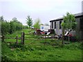
Bus depot?
The Macmillan Way guidebook says "go past main bus garage at back of Lawns Farm". True there was a bus in the building on the right but the description implied something more grand. The main feature of this part of Lawns Farm is the proliferation of abandoned vehicles and vehicle parts.
Image: © Graham Horn
Taken: 4 May 2007
0.21 miles
2
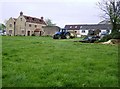
Nutty Coppice Farm
The stone farmhouse looks relatively new. Being on a slight rise, it has a fine view northwards (left) towards Trudoxhill and Frome.
Image: © Graham Horn
Taken: 4 May 2007
0.24 miles