IMAGES TAKEN NEAR TO
Marston Bigot, FROME, BA11 5BR
Introduction
This page details the photographs taken nearby to BA11 5BR by members of the Geograph project.
The Geograph project started in 2005 with the aim of publishing, organising and preserving representative images for every square kilometre of Great Britain, Ireland and the Isle of Man.

There are currently over 7.5m images from over14,400 individuals and you can help contribute to the project by visiting https://www.geograph.org.uk
Image Map
Images are licensed for reuse under creativecommons.org/licenses/by-sa/2.0
Notes
- Clicking on the map will re-center to the selected point.
- The higher the marker number, the further away the image location is from the centre of the postcode.
Image Listing (10 Images Found)
Images are licensed for reuse under creativecommons.org/licenses/by-sa/2.0
Image
Details
Distance
1
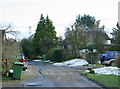
2009 : The far end of Smithick's Lane
If you go any further you will have to back up.
Looks like a "green bin" day.
Image: © Maurice Pullin
Taken: 10 Feb 2009
0.01 miles
2
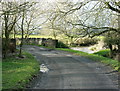
2009 : Smithick's Bridge
Carries Smithick's Lane over the River Frome.
From here the Frome passes through Frome (oh! yes it does) then on to Rode and Farleigh Hungerford, meeting the River Avon near Iford.
The name Frome means river in early English, so does the name Avon. So we have the spectacle of the River River flowing into the River River.
Image: © Maurice Pullin
Taken: 10 Feb 2009
0.06 miles