IMAGES TAKEN NEAR TO
Critch Hill, FROME, BA11 4LJ
Introduction
This page details the photographs taken nearby to Critch Hill, BA11 4LJ by members of the Geograph project.
The Geograph project started in 2005 with the aim of publishing, organising and preserving representative images for every square kilometre of Great Britain, Ireland and the Isle of Man.

There are currently over 7.5m images from over14,400 individuals and you can help contribute to the project by visiting https://www.geograph.org.uk
Image Map (Loading...)


Getting Data...Please wait
Leaflet Map data © OpenStreetMap
Images are licensed for reuse under creativecommons.org/licenses/by-sa/2.0
Notes
- Clicking on the map will re-center to the selected point.
- The higher the marker number, the further away the image location is from the centre of the postcode.
Image Listing (4 Images Found)
Images are licensed for reuse under creativecommons.org/licenses/by-sa/2.0
Image
Details
Distance
2
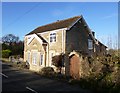
Old Toll House, Critch Hill
Toll House in the parish of Nunney, Turnpike Cottage, Critch Hill, BA11 4LJ.
Somerset HER.
HER number: 37397 https://www.heritagegateway.org.uk/Gateway/Results_Single.aspx?uid=37397&resourceID=100
Surveyed
Milestone Society National ID: SO.SEL02
Image: © Alan Rosevear
Taken: 1 Dec 2012
0.11 miles
3

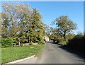
2008 : On the Nunney Road at the foot of Critch Hill
A narrow winding road barely able to take its traffic. Few stopping places, very dangerous for walking and cycling.
Image: © Maurice Pullin
Taken: 9 Dec 2008
0.13 miles
4
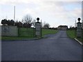
Frome Golf Club
The drive up to Frome Golf Club.
Image: © Graham Richards
Taken: 21 Jan 2006
0.21 miles