IMAGES TAKEN NEAR TO
Upper Whatcombe, FROME, BA11 3SA
Introduction
This page details the photographs taken nearby to Upper Whatcombe, BA11 3SA by members of the Geograph project.
The Geograph project started in 2005 with the aim of publishing, organising and preserving representative images for every square kilometre of Great Britain, Ireland and the Isle of Man.

There are currently over 7.5m images from over14,400 individuals and you can help contribute to the project by visiting https://www.geograph.org.uk
Image Map
Images are licensed for reuse under creativecommons.org/licenses/by-sa/2.0
Notes
- Clicking on the map will re-center to the selected point.
- The higher the marker number, the further away the image location is from the centre of the postcode.
Image Listing (13 Images Found)
Images are licensed for reuse under creativecommons.org/licenses/by-sa/2.0
Image
Details
Distance
1
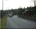
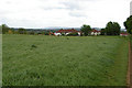
2009 : Whatcombe Road Frome
Looking toward the town centre.
Image: © Maurice Pullin
Taken: 8 Dec 2009
0.02 miles
2
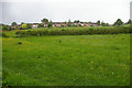
View to Frome
View from the bank of the River From to housing on Whatcombe Road, Frome.
Image: © Roger Gittins
Taken: 18 May 2009
0.03 miles

5
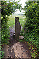
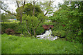
Why go over when you can go round?
Not seen a stile like this before. Is it peculiar to Somerset?
Image: © Roger Gittins
Taken: 18 May 2009
0.14 miles
7
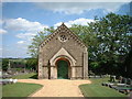
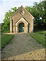
Frome Dissenters Cemetery Chapel
View of Chapel from Vallis Road
Image: © Jim Parsons
Taken: 26 Nov 2007
0.15 miles
8

2009 : A362 Vallis Road Frome
Less than a mile from the town centre.
The hill in the distance is Cley Hill near Warminster Image
Image: © Maurice Pullin
Taken: 8 Dec 2009
0.18 miles
9
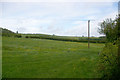
View back to A362 at top of the hill
From the bank of the River Frome. The junction of A362 and Jack's Lane is right of centre on the horizon, where there is a stile.
Image: © Roger Gittins
Taken: 18 May 2009
0.19 miles
10
Outskirts of Frome
From the East Mendips Way approaching Frome. In the far distance on the escarpment is Westbury White Horse; see square Image
Image: © Roger Gittins
Taken: 19 May 2009
0.19 miles