IMAGES TAKEN NEAR TO
Linnet Way, FROME, BA11 2UY
Introduction
This page details the photographs taken nearby to Linnet Way, BA11 2UY by members of the Geograph project.
The Geograph project started in 2005 with the aim of publishing, organising and preserving representative images for every square kilometre of Great Britain, Ireland and the Isle of Man.

There are currently over 7.5m images from over14,400 individuals and you can help contribute to the project by visiting https://www.geograph.org.uk
Image Map (Loading...)


Getting Data...Please wait
Leaflet Map data © OpenStreetMap
Images are licensed for reuse under creativecommons.org/licenses/by-sa/2.0
Notes
- Clicking on the map will re-center to the selected point.
- The higher the marker number, the further away the image location is from the centre of the postcode.
Image Listing (2 Images Found)
Images are licensed for reuse under creativecommons.org/licenses/by-sa/2.0
Image
Details
Distance
1
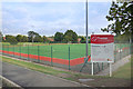
All Weather Pitches, Frome Leisure Centre
Image: © Des Blenkinsopp
Taken: 30 Jul 2019
0.19 miles
2
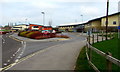
Frome Community Hospital
Set back from the northeast side of Rodden Road, accessed via Enos Way.
Image: © Jaggery
Taken: 11 Mar 2017
0.24 miles