IMAGES TAKEN NEAR TO
Buckland Dinham, FROME, BA11 2QL
Introduction
This page details the photographs taken nearby to BA11 2QL by members of the Geograph project.
The Geograph project started in 2005 with the aim of publishing, organising and preserving representative images for every square kilometre of Great Britain, Ireland and the Isle of Man.

There are currently over 7.5m images from over14,400 individuals and you can help contribute to the project by visiting https://www.geograph.org.uk
Image Map (Loading...)


Getting Data...Please wait
Leaflet Map data © OpenStreetMap
Images are licensed for reuse under creativecommons.org/licenses/by-sa/2.0
Notes
- Clicking on the map will re-center to the selected point.
- The higher the marker number, the further away the image location is from the centre of the postcode.
Image Listing (33 Images Found)
Images are licensed for reuse under creativecommons.org/licenses/by-sa/2.0
Image
Details
Distance
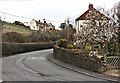
1

Entering Buckland Dinham from south
In the foreground, just beyond this junction with unnamed lane from Frogs Bottom is a bridge over Buckland Brook.
Notice the signs for "wild fowl in road ahead" along with community speedwatch.
Image: © Roger Gittins
Taken: 19 May 2009
0.03 miles
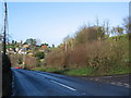
2
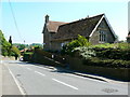
2008 : Up the hill to Buckland Dinham
Standing at the end of Lower Street looking north along the A362.
Image: © Maurice Pullin
Taken: 31 Mar 2008
0.04 miles
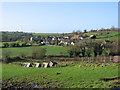
3

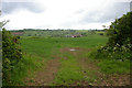
Down towards Hope Farm
This field was a bit squelchy and whiffy; wet slurry had recently (within the last hour probably) been laid for soil enrichment.
Image: © Graham Horn
Taken: 3 May 2007
0.10 miles
4

Macmillan Way West (part of)
Part of the Macmillan (as in cancer support) Way; a long distance path from Lincolnshire to Dorset. http://www.macmillanway.org/
This is part of the branch path from Dorset to Devon.
Image: © Roger Gittins
Taken: 19 May 2009
0.12 miles
5
Mount Pleasant
A view looking north along the A362 at Mount Pleasant towards Buckland Dinham. The junction with Murtry Hill Lane is at right.
Image: © Phil Williams
Taken: 3 Dec 2006
0.12 miles
6
View from Mount Pleasant
A view looking west from Mount Pleasant over a smallholding by the Buckland Brook. The chimney at the disused colliery at OS square ST7450 can be seen above the sheds of Dangerfield Farm, just left of centre.
Image: © Phil Williams
Taken: 3 Dec 2006
0.12 miles
7
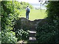
Which way now? Leaving Buckland Dinham
Once over this interesting stone stile, another field; so check the map again for directions. Straight on with the hedge on the left as it happens.
Image: © Graham Horn
Taken: 3 May 2007
0.15 miles
8
View to Buckland Dinham
View to Dangerfield Farm, Buckland Dinham
Image: © Roger Gittins
Taken: 20 May 2009
0.16 miles
9
Buckland Dinham village hall, Buckland Dinham - polling station duties
03 May 2007, the nation goes to vote. Well, maybe. Not doing a roaring trade here just after lunch.
Image: © Brian Robert Marshall
Taken: 3 May 2007
0.18 miles
10
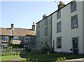
Contrasting buildings in Buckland Dinham
Contrasting styles of stone houses found in the southern part of the village.
Image: © Graham Horn
Taken: 3 May 2007
0.19 miles