IMAGES TAKEN NEAR TO
Standerwick, FROME, BA11 2PR
Introduction
This page details the photographs taken nearby to BA11 2PR by members of the Geograph project.
The Geograph project started in 2005 with the aim of publishing, organising and preserving representative images for every square kilometre of Great Britain, Ireland and the Isle of Man.

There are currently over 7.5m images from over14,400 individuals and you can help contribute to the project by visiting https://www.geograph.org.uk
Image Map (Loading...)


Getting Data...Please wait
Leaflet Map data © OpenStreetMap
Images are licensed for reuse under creativecommons.org/licenses/by-sa/2.0
Notes
- Clicking on the map will re-center to the selected point.
- The higher the marker number, the further away the image location is from the centre of the postcode.
Image Listing (42 Images Found)
Images are licensed for reuse under creativecommons.org/licenses/by-sa/2.0
Image
Details
Distance
1
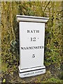
Milepost by the former A36, Standerwick
Cast iron post by the UC road (was A36), in parish of Beckington (Mendip District), Leigh Farm, Standerwick, where old road is walled off, against hedge by drive, on South-southwest side of road. C&M Classical iron casting, erected by the Black Dog Turnpike Trust in the 19th century.
Inscription reads:-
BATH
12
WARMINSTER
5
BERKLEY PARISH
Milestone Society National ID: SO_BAWM12.
Image: © Milestone Society
Taken: 11 Mar 2016
0.08 miles
3
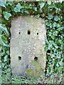
Old Milestone by the former A36, Standerwick
Stone post (plate lost) by the UC road (was A36), in parish of Beckington (Mendip District), Leigh Farm, Standerwick, where old road is walled off, against hedge on opposite side of entrance to the newer post, on South-southwest side of road. Black Dog Stone, erected by the Black Dog Turnpike Trust in the 18th century.
Inscription once read:-
(Bath 12)
(Warminster 5)
Milestone Society National ID: SO_BAWM12a.
Image: © Milestone Society
Taken: 11 Mar 2016
0.08 miles
4
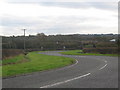
Standerwick
Looking south to the bridge carrying the rail line over a minor road at Standerwick. The roof of one of the buildings at Frome Cattle Market can be seen at centre right.
Image: © Phil Williams
Taken: 4 Dec 2005
0.16 miles
5
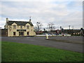
Standerwick Cross
Looking northeast to the Bell public house at Standerwick Cross on the A36.
Image: © Phil Williams
Taken: 4 Dec 2005
0.17 miles
6
Towards Standerwick
This scene always seems to catch people's eye from the train. Here is another interpretation by Lewis Clarke Image The pub is The Bell.
This photo was taken from the 1158 Penzance to London Paddington train, having left Castle Cary at 1550.
Image: © Graham Horn
Taken: 9 Jul 2011
0.17 miles
7

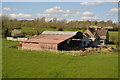
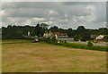
2008 : Leigh Farm, Standerwick
Farm buildings associated with Leigh Farm.
A small lump can be seen on the horizon to the far right, this is Cley Hill Image near Warminster.
Image: © Maurice Pullin
Taken: 5 Jan 2008
0.17 miles
8

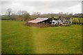
2008 : The Bell, Standerwick
Little local trade here, they probably get most of their business from passing trade and visitors to Frome market on the other side of the A36. http://www.thebellatstanderwick.co.uk/
Image: © Maurice Pullin
Taken: 19 Feb 2008
0.17 miles