IMAGES TAKEN NEAR TO
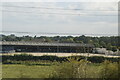
Standerwick, FROME, BA11 2PN
Introduction
This page details the photographs taken nearby to BA11 2PN by members of the Geograph project.
The Geograph project started in 2005 with the aim of publishing, organising and preserving representative images for every square kilometre of Great Britain, Ireland and the Isle of Man.

There are currently over 7.5m images from over14,400 individuals and you can help contribute to the project by visiting https://www.geograph.org.uk
Image Map (Loading...)


Getting Data...Please wait
Leaflet Map data © OpenStreetMap
Images are licensed for reuse under creativecommons.org/licenses/by-sa/2.0
Notes
- Clicking on the map will re-center to the selected point.
- The higher the marker number, the further away the image location is from the centre of the postcode.
Image Listing (31 Images Found)
Images are licensed for reuse under creativecommons.org/licenses/by-sa/2.0
Image
Details
Distance
1
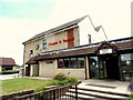
Frome Livestock Market
One of the original dwellings, probably a farmhouse or cottage, which has been converted into the Market Office.
Image: © Sarah Smith
Taken: 7 Jul 2017
0.00 miles
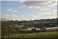
2
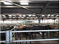
Frome Livestock Market
A view of the pens where the cattle are efficiently dispatched into the sale ring by a series of swinging gates.
Image: © Sarah Smith
Taken: 7 Jul 2017
0.03 miles
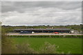
3
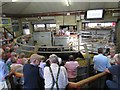
Frome Livestock Market - Auction ring
Here is the sale ring where the cattle are bought. These are stores - younger cattle who will be fattened on another farm. The screen up on the left shows the Lot no, breed, date of birth and TB test date.
Image: © Sarah Smith
Taken: 7 Jul 2017
0.03 miles
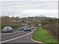
7
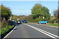
Junction of A36 and B3099
Looking in the Bath direction. The B3099 goes towards Westbury.
Image: © Robin Webster
Taken: 13 Nov 2022
0.09 miles
8
A36 at Standerwick
Looking northwest from the junction of the B3099 with the A36 at Standerwick. The bridge carries the Paddington-Penzance rail line.
Image: © Phil Williams
Taken: 4 Dec 2005
0.11 miles
9
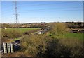
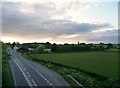
A36 near Standerwick
Looking in the other direction from Image along the main road as it approaches Frome Market, from a passing train on the main railway line. The road passes beneath a power line, and the roadsign indicates the junction with the B3099 to Dilton Marsh on the left.
Image: © Derek Harper
Taken: 19 Mar 2012
0.11 miles