IMAGES TAKEN NEAR TO
Welshmill Lane, FROME, BA11 2LL
Introduction
This page details the photographs taken nearby to Welshmill Lane, BA11 2LL by members of the Geograph project.
The Geograph project started in 2005 with the aim of publishing, organising and preserving representative images for every square kilometre of Great Britain, Ireland and the Isle of Man.

There are currently over 7.5m images from over14,400 individuals and you can help contribute to the project by visiting https://www.geograph.org.uk
Image Map (Loading...)


Getting Data...Please wait
Leaflet Map data © OpenStreetMap
Images are licensed for reuse under creativecommons.org/licenses/by-sa/2.0
Notes
- Clicking on the map will re-center to the selected point.
- The higher the marker number, the further away the image location is from the centre of the postcode.
Image Listing (20 Images Found)
Images are licensed for reuse under creativecommons.org/licenses/by-sa/2.0
Image
Details
Distance
1
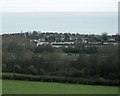
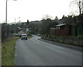
2009 : Innox Hill Frome from Whatcombe Road
We are allowed a few minor glimpses of the River Frome at the bottom of the frame, then over to Innox Hill on the other side of the valley.
"Frome" means "river" in old English, apparently. So the River River is now flowing north of... River?
Image: © Maurice Pullin
Taken: 8 Dec 2009
0.16 miles
2
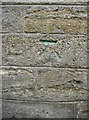
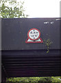
Green for a change
It's not unknown for old benchmarks to be resurveyed and a touch of yellow paint applied to aid the location, but not green. Perhaps it was made by someone other than a surveyor. See http://www.bench-marks.org.uk/bm57383 for the entry in the Benchmark Database and Image] for a wider view.
Image: © Neil Owen
Taken: 13 May 2014
0.17 miles
4
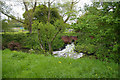
Why go over when you can go round?
Not seen a stile like this before. Is it peculiar to Somerset?
Image: © Roger Gittins
Taken: 18 May 2009
0.17 miles
5

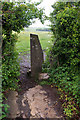
More going up
The Welshmill Lane area has had a lot of old industrial buildings demolished and now more residential developments await.
Image: © Neil Owen
Taken: 13 May 2014
0.17 miles
6
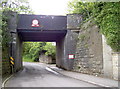
Welshmill Lane railway bridge
Part of the G.W.R. (Radstock branch) railway line into Frome. There is a benchmark on the stone block walling to the right - see Image Interestingly, the single road section underneath it is not light-controlled. Also see Image] for a closer look at the signs above.
Image: © Neil Owen
Taken: 13 May 2014
0.17 miles
7
A change of emphasis
The sign above the Welshmill Lane railway bridge overlays an earlier one - and a triangular one at that. The Highway Code lists triangular signs as being warnings (mostly) whereas the circular give orders. See Image] for another view.
Image: © Neil Owen
Taken: 13 May 2014
0.17 miles
8

2009 : Railway bridge over Welshmill Lane, Frome
The bridge carries a mineral line. It has a height restriction of 14ft 6ins (4.4m).
Image: © Maurice Pullin
Taken: 8 Dec 2009
0.18 miles
9

Two into one
This section of Welshmill Lane divides into two for a short run, just before it returns to a single carriageway. However, just after that it becomes a single track as it passes under the railway bridge - all without the aid of traffic lights! See Image] for another view.
Image: © Neil Owen
Taken: 13 May 2014
0.18 miles
10
2009 : Whatcombe Road Frome
Looking toward the town centre.
Image: © Maurice Pullin
Taken: 8 Dec 2009
0.19 miles